The Cabot Trail is a scenic route in the Canadian province of Nova Scotia. in northern Victoria County and Inverness County on Cape Breton Island.
The route is 298 km long and completes a detour around the northern tip of the island, passing along and through Cape Breton Highlands. It is named after the explorer John Cabot, who landed in the Canadian Atlantic in 1497, although most historians agree that his probable landing took place in Newfoundland and not on the island. of Cape Breton.
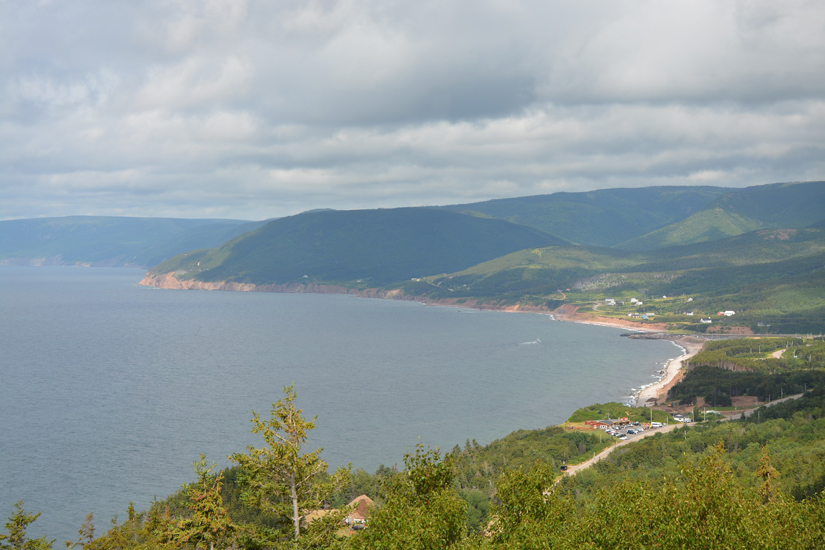
The northern section passes through Cape Breton Highlands National Park. The eastern and western sections follow the steep coastline, providing spectacular views of the ocean. The southwest section passes through the valley of the Margaree River before passing by Lake Bras d’Or.
The Cabot Trail is one of the most famous road circuits recognized as Provincial Route 30 (Trunk 30) by the Nova Scotia Department of Transportation.
Access : Coordinates: 46.486944, -60.746111 / Route information : Length 298 km (185 mi) , East end Hwy 105 (TCH) at Buckwheat Corne – Route 312 in River Bennet – Route 219 in Margaree Harbou – Trunk 19 in Margaree Forks , West end Hwy 105 (TCH) at South Haven , Counties : Victoria County, Inverness County /
Highlights :
- The trail is named after John Cabot, who was the first European to explore the island in 1497. Construction of the original trail was completed in 1932. The highway has been expanded several times since then.
- Lakie’s Head : Enjoy the great views from Lakie’s Head , A great place to watch whales offshore.
- Mount North Lookout – Aspy Fault : The Aspy fault stretches inland for approximately 40 kilometers (24 miles). Land masses move and separate along fault lines.
- The Lone Shieling : The only authorized way to get to this old-growth deciduous forest is to follow the walking trail (20 minutes). Stay on the trail to limit damage from trampling.
- MacIntosh Brook Trail : MacIntosh Brook Campground is a small, open area nestled at the base of the mountains Located in the Grande Anse Valley, 5 km from Pleasant Bay.
- Pleasant Bay : Pleasant Bay is a community on the west coast of Cape Breton Island, in Inverness County, Nova Scotia. he community is located on the Cabot Trail, 141 kilometers from Port Hawkesbury. The federal electoral district is Sydney — Victoria
- Mount MacKenzie Lookout : The highland plateau covers more than 90% of the park area , the plateau is very rugged, deeply indented by valleys and dotted with shallow lakes and peat bogs.
- Fishing Cove : 1165 feet above sea level! Trailhead: On the Cabot Trail at the top of MacKenzie Mountain. Explore the beach, roam the hills or swim in fresh or salt water.
- Skyline Trail : The Skyline Trail is a seven-kilometre, looping, hiking trail at Cape Breton Highlands National Park in Nova Scotia, Canada. It lies on the western side of the Cabot Trail, near French Mountain’s summit. This trail is well known for its scenic views, but also for the 2009 fatal coyote assault on Taylor Mitchell.
- Cap Rouge : Cap-Rouge was an Acadian village located on Cape Breton Island, north of Chéticamp, Nova Scotia. It was evacuated in 1939 when Cape Breton Highlands National Park was founded, when Scottish villages like Pleasant Bay have been preserved. The former village site is accessible located on the Cabot Trail across from the Trout Brook picnic area
- The war veterans monument : The monument dominates the breathtaking view of the west coast. World-famous views from the Veterans Monument lookout.During Parks Canada’s centennial year in 1985, the Department of Veterans Affairs installed a commemorative plaque at this location in recognition of the contribution of Canadians who died overseas during the two world wars.
Communities :
- Baddeck, gateway to the Cabot Trail, where Alexander Graham Bell National Historic Site is located.
- Belle-Côte, a small fishing village located at the mouth of the Margaree River
- Chéticamp, Acadian fishing village, famous for its hooked rugs, located west of Cape Breton Highlands National Park.
- Cape North, village where the North Highlands Community Museum is located.
- Ingonish, a fishing village and one of the first settlements founded on Cape Breton Island,One of the most developed spots along the Cabot Trail.
- St. Anns, home of the Gaelic College of Celtic Arts and Crafts (Cape Breton Gaelic Museum of Arts and Crafts)
Activities : Scenic Driving- Auto Touring / sightseeing / photo opportunities / Long distance walking – trekking,This tourist route is open all year round. / Scenic tours along the Cabot Trail / Enjoy the most spectacular views in Atlantic Canada .
Go next : South Haven. The scenic travelway known as the “Cabot Trail” includes all of Trunk 30, as well as the portion of Highway 105 between exits 7 and 11.