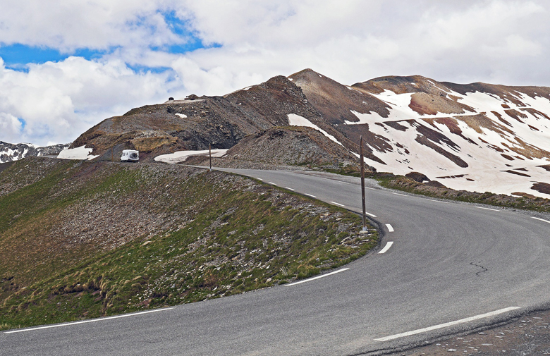
Col de la Bonette – Bonette Pass (2715 masl) is a mountain pass in the French Alps, near the border with Italy. It is located in the Mercantour National Park on the border of the departments of Alpes-Maritimes and Alpes-de-Haute-Provence.
This old strategic route was only a mule track It was enlarged in 1832, but the present road was not completed until 1964. The road was classified imperial road August 18, 1860 by the Emperor Napoleon III.
1931-1940 bunkers of the Maginot Line were built, above the road between the pass heights of Restefond and Bonette.
1960-1961 the current street was built, as can be seen from the memorial stone at the highest point.
The top of the Bonette is a summit located in the Mercantour-Argentera massif, between the Alpes-de-Haute-Provence and the Alpes-Maritimes, dominating in the north the valley of Ubaye and south Tinee. It’s one of the highest mountain roads of Europe.
Col de la Bonette is at 2715 metres and the road directly crosses the col ,This is not the highest asphalt road in Europe as suggested by the local tourist signs. The Pico Veleta in Spain in Sierra Nevada with its 3396 m takes the first step of the podium. In the Alps, the south gate of the Otztaler Gletscherstrasse tunnel (2,829 meters) in Austria is at the top of the list. Cocorico with the Col de l’Iseran and 2770 m which is therefore the highest pass in Europe .
Starting from the valley of Ubaye (Jausiers), the departmental 64 passes near the “Faux col Restefond” (04-2639). Nearby, because the pass is a little below the paved road, on a track R1 which leads to the Col de la Moutiere.The average ascent percentage of the Col de la Bonette is 6.4% from the south and 6.6% from the north, with a maximum increase of 10% and 9% respectively. In elevation meters, the rise from the south is 1652 meters and from the north 1589 meters. The Cime de la Bonette is a lot steeper with an average gradient of 15%.
Description :
- The Col de la Bonette road (altitude 2,715 metres) links the Ubaye Valley in the Alpes de Haute Provence to the Tinee Valley in the Alpes-Maritimes.
- Col de la Bonette is the second highest paved through route in the Alps , The road around the Top of the Bonette reaches an altitude of 2802 m, but this is not a “step”, but simply a scenic circuit. It is, however..is the highest road in France and one of the highest in Europe.
- It is also the highest point reached by the Tour de France in the 2008 Tour de France passed in stage 16 of the Tour and when he approaches the summit of Saint-Etienne-de-Tinee (southeast), and after arriving at the Col de la Bonette, which is the highest point reached by the Tour de France.
- From the highest point , where there is a memorial stone and a small parking lot you can enjoy fabulous panoramic view of the national park.
Points of Interest:
- Le fortin du Restefond – Restefond Fort, or barracks of the Restefond, is a barracks located at 2,558 m altitude, about 2 km below the Restefond pass, down to Jausiers
- the ruins of the Camp des Fourches , barracks built here before WWI. The Camp des Fourches is a mountain barracks located at 2,291 m altitude, in the Mercantour Massif, on the Route de la Bonette (M2205), about 8 km from the Col de la Bonette,
– - Tinee Valley , The Tinee river begins at the Col de la Bonette, 2802 m high, in the Parc du Mercantour and runs south-southeast down through beautiful forested valleys and canyons to the Var river, where the Var bends to the south just above Plan-du-Var, only 25 km from Nice.
- remnants of the Maginot Line’s Alpine extension, the Alpine Line,
ATTENTION: the Col des Fourches is in the Mercantour National Park! / The pass is closed a large part of the year. By the end of spring the closing can be partial, at night for example. Check before you set off.
Access : Coordinates: 44.321667, 6.806944 / Cime de la Bonette Located in the eastern part of the country, it is 600 km southeast of Paris,
Infrastructure on the pass : Halte 2000 mountain restaurant / A bike lane was built in the direction of climbing on many sections./ milestones with several information (altitude, percentage of the kilometer to come, distances to important localities
Activities : Villages Tours / adventure tourism / photo opportunities / Scenic Driving- Auto Touring / cycling , The top of the Bonette is the mecca of the cyclo-climber! With its 2802 m, it is the highest asphalt road in France. / Hiking . From the top of this road, a small footpath allows to climb to the top of the mountain at 2,860 meters. / Motorcycle Touring
Buy :
Eat : Drink : Accommodation :
Go next : Jausiers / Mercantour National Park / La Vallee de la Tinee – the Tinee Valley / Col de Restefond – Restefond pass /