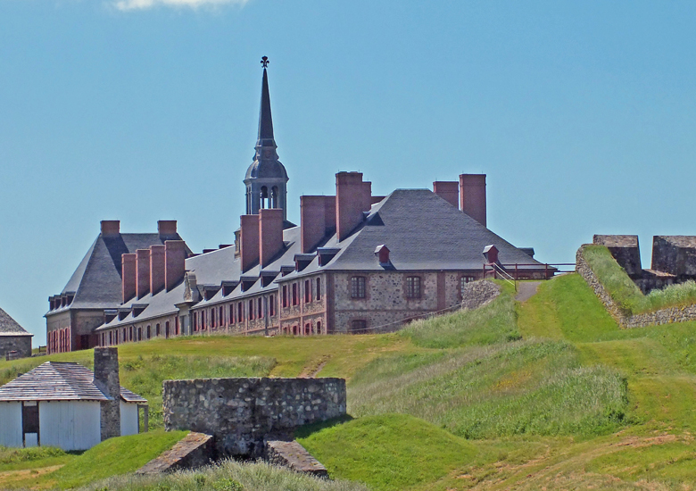
The Fortress of Louisbourg (French: Forteresse de Louisbourg) is a National Historic Site of Canada and the location of a one-quarter partial reconstruction of an 18th-century French fortress at Louisbourg on Cape Breton Island, Nova Scotia.
Its two sieges, especially that of 1758, were turning points in the Anglo-French struggle for what today is Canada. The original settlement was made in 1713, and initially called Havre a l’Anglois. Subsequently, the fishing port grew to become a major commercial port and a strongly defended fortress. The fortifications eventually surrounded the town. The walls were constructed mainly between 1720 and 1740. By the mid-1740s Louisbourg, named for Louis XIV of France, was one of the most extensive (and expensive) European fortifications constructed in North America. It was supported by two smaller garrisons on Ile Royale located at present-day St. Peter’s and Englishtown.
The Fortress of Louisbourg suffered key weaknesses, since it was erected on low-lying ground commanded by nearby hills and its design was directed mainly toward sea-based assaults, leaving the land-facing defences relatively weak. A third weakness was that it was a long way from France or Quebec, from which reinforcements might be sent. It was captured by British colonists in 1745, and was a major bargaining chip in the negotiations leading to the 1748 treaty ending the War of the Austrian Succession. It was returned to the French in exchange for border towns in what is today Belgium. It was captured again in 1758 by British forces in the Seven Years’ War, after which its fortifications were systematically destroyed by British engineers. The British continued to have a garrison at Louisbourg until 1768.
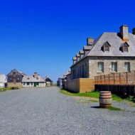
The fortress and town were partially reconstructed in the 1960s and 1970s, using some of the original stonework, which provided jobs for unemployed coal miners. The head stonemason for this project was Ron Bovaird. The site is operated by Parks Canada as a living history museum. The site stands as the largest reconstruction project in North America.
History : French settlement on Ile Royale (now Cape Breton Island) can be traced to the early 17th century following settlements in Acadia that were concentrated on Baie Francaise (now the Bay of Fundy) such as at Port-Royal and other locations in present-day peninsular Nova Scotia. A French settlement at Sainte Anne (now Englishtown) on the central east coast of Ile Royale was established in 1629 and named Fort Sainte Anne, lasting until 1641. A fur trading post was established on the site from 1651–1659, but Ile Royale languished under French rule as attention was focused on the St. Lawrence River/Great Lakes colony of Canada (which then comprised parts of what is now Quebec, Ontario, Michigan, Ohio, Indiana, Wisconsin and Illinois), Louisiana (which encompassed the current Mississippi Valley states and part of Texas), and the small agricultural settlements of mainland Acadia.

The Treaty of Utrecht in 1713 gave Britain control of part of Acadia (peninsular Nova Scotia) and Newfoundland; however, France maintained control of its colonies at Ile Royale, Ile St-Jean (now Prince Edward Island), Canada and Louisiana, with Ile Royale being France’s only territory directly on the Atlantic seaboard (which was controlled by Britain from Newfoundland to present-day South Carolina) and it was strategically close to important fishing grounds on the Grand Banks of Newfoundland, as well as being well placed for protecting the entrance to the Gulf of St. Lawrence.
In 1713, France set about constructing Port Dauphin and a limited naval support base at the former site of Fort St-Anne; however, the winter icing conditions of the harbour led the French to choose another harbour on the southeastern part of Ile Royale. The harbour, being ice-free and well protected, soon became a winter port for French naval forces on the Atlantic seaboard and they named it Havre Louisbourg after King Louis XIV.
First siege : The Fortress was besieged in 1745 by a New England force backed by a Royal Navy squadron. The New England attackers succeeded when the fortress capitulated on June 16, 1745. A major expedition by the French to recapture the fortress led by Jean-Baptiste de La Rochefoucauld de Roye, duc d’Anville, the following year was destroyed by storms, disease and British naval attacks before it ever reached the fortress.
Louisbourg returned : In 1748, the Treaty of Aix-la-Chapelle, which ended the War of the Austrian Succession, restored Louisbourg to France in return for territory gained in the Austrian Netherlands and the British trading post at Madras in India. Maurepas, the ministre de la marine, was determined to have it back. He regarded the fortified harbour as essential to maintaining French dominance in the fisheries of the area. The disgust of the French in this transaction was matched by that of the English colonists. The New England forces left, taking with them the famous Louisbourg Cross, which had hung in the fortress chapel. This cross was rediscovered in the Harvard University archives only in the later half of the 20th century it is now on long-term loan to the Louisbourg historic site.
Second siege : Britain’s American colonies were expanding into areas claimed by France by the 1750s, and the efforts of French forces and their Indian allies to seal off the westward passes and approaches through which American colonists could move west soon led to the skirmishes that developed into the French and Indian War in 1754. The conflict widened into the larger Seven Years’ War by 1756, which involved all of the major European powers.
A large-scale French naval deployment in 1757 fended off an attempted assault by the British in 1757. However, inadequate naval support the following year allowed a large British combined operation to land for the 1758 Siege of Louisbourg which ended after a siege of six weeks on 26 July 1758, with a French surrender. The fortress was used by the British as a launching point for its 1759 Siege of Quebec that culminated in the Battle of the Plains of Abraham.
The fortifications at Louisbourg were systematically destroyed by British engineers in 1760 to prevent the town and port from being used in the future by the French, should the peace process return Cape Breton island to France. The British kept a garrison at Louisbourg until 1768. Some of the cut-stones from Louisbourg were shipped to Halifax to be re-used and, in the 1780s, to Sydney, Nova Scotia.
20th century : The site of the fortress was designated a National Historic Site in 1920. Beginning in 1961, the government of Canada undertook a historical reconstruction of one quarter of the town and fortifications with the aim being to recreate Louisbourg as it would have been at its height in the 1740s. The work required an interdisciplinary effort by archaeologists, historians, engineers, and architects. The reconstruction was aided by unemployed coal miners from the industrial Cape Breton area, many of whom learned French masonry techniques from the 18th century and other skills to create an accurate replica. Where possible, many of the original stones were used in the reconstruction.
Dozens of researchers worked on the project over the span of five decades. They included British-born archaeologists Bruce W. Fry and Charles Lindsay; and Canadian historians B. A. Balcom, Kenneth Donovan, Brenda Dunn, John Fortier, Margaret Fortier, Allan Greer, A.J.B. Johnston, Eric Krause, Anne Marie Lane Jonah, T.D. MacLean, Christopher Moore, Robert J. Morgan, Christian Pouyez and Gilles Proulx. There were many more. Among the architects, Yvon LeBlanc, one of the first Acadian architects, was responsible for most of town-site buildings, with input from researchers who contributed to various committees.
Today, the entire site of the fortress, including the one-quarter reconstruction, is the Fortress of Louisbourg National Historic Site of Canada, operated by Parks Canada. Offerings include guided and unguided tours, and the demonstration and explanation of period weapons, including muskets and a cannon. Puppet shows are also shown. The Museum / Caretakers Residence (ca. 1935-6) within the site is a Classified Federal Heritage Building. The fortress has also greatly aided the local economy of the town of Louisbourg, as it has struggled to diversify economically with the decline of the North Atlantic fishery.
On 5 May 1995, Canada Post issued the ‘Fortress of Louisbourg’ series to mark the 275th anniversary of the official founding of the fortress, the 250th anniversary of the siege by the New Englanders, the 100th anniversary of the commemoration by the Society of Colonial Wars, and the 100th anniversary of the arrival of the Sydney and Louisburg Railway (S & L). The Fortress of Louisbourg series includes: ‘The Harbour and Dauphin Gate’ ’18th Century Louisbourg’ ‘The King’s Bastion’ ‘The King’s Garden, Convent, Hospital, and British Barracks’ and ‘The Fortifications and Ruins Fronting the Sea and Rochfort Point’ The 43 stamps were designed by Rolf P. Harder.
The museum that operates from the Fortress is affiliated with: CMA, CHIN, and Virtual Museum of Canada.
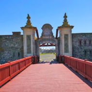
Fortified town : The Fortress of Louisbourg was the capital for the colony of Ile-Royale, and was located on the Atlantic coast of Cape Breton Island near its southeastern point. The location for the fortress was chosen because it was easy to defend against British ships attempting to either block or attack the St. Lawrence River, at the time the only way to get goods to Canada and its cities of Quebec and Montreal. South of the fort, a reef provided a natural barrier, while a large island provided a good location for a battery. These defences forced British ships to enter the harbour via a 500-foot (150 m) channel. The fort was built to protect and provide a base for France’s lucrative North American fishery and to protect Quebec City from British invasions. For this reason it has been given the nicknames ‘Gibraltar of the North’ or the ‘Dunkirk of America.’ The fort was also built to protect France’s hold on one of the richest fishing grounds in the world, the Grand Banks. One hundred and sixteen men, ten women, and twenty-three children originally settled in Louisbourg.
Access : Coordinates: 45.892382, -59.98621 / By land: After crossing the Canso Causeway, you will be faced with two options: 1) Take Highway 105, the Trans-Canada Highway. At Bras d’Or, take Highway 125 to Sydney until you reach Exit 8 then take the first exit off the roundabout, onto Route 22. This route will take you straight to the modern community of Louisbourg. Follow the signs to the Fortress of Louisbourg National Historic Site. Approximate travel time: 3 hours.
2) Take Route 4, also called Highway 104. In Sydney River, take the turn-off onto Highway 125, then take Exit 8, taking the first exit off the roundabout, onto Route 22. This route will take you straight to the modern community of Louisbourg. Follow the signs to the Fortress of Louisbourg National Historic Site. Approximate travel time: 2.5 hours.
By air: The J.A. Douglas McCurdy Sydney Airport now offers direct daily flights between Sydney and Toronto, as well as daily flights between Sydney and Halifax. Please check their website for further information.
From the J.A. Douglas McCurdy Sydney Airport, turn left onto Trunk 4 West toward Sydney. After 8 km, turn left onto NS-125 W. After 3.5 km, take Exit 8 for Route 22, and turn left at the bottom of the off-ramp. Continue on Route 22 through the roundabout. This route will take you straight to the modern community of Louisbourg. Follow the signs for the Fortress of Louisbourg National Historic Site. Approximate driving time: 35 minutes.
Months of Operation : May 22 – October 15 ( some parts are open year-round.) / Hours : 9:30am–5pm