The Kilimanjaro is a mountain range in Tanzania on the border with Kenya. The highest peak is called “Uhuru Peak” and is also the highest point of Africa. Founded in 1973, Kilimanjaro National Park has been a UNESCO World Heritage Site since 1987.
Kilimanjaro is located about 340 km south of Ecuador, northeast of Tanzania, about 500 km northwest of Dar es Salaam and about 560 km southeast of Lake Victoria center. Only a few kilometers from the border with Kenya, Kilimanjaro lies about 200 km southeast of Nairobi, the capital of this country.
After the surprise caused in the scientific world by his contemporary discovery in 1848 by Johannes Rebmann, Kilimanjaro aroused the interest of explorers such as Hans Meyer and Ludwig Purtscheller, who reached the summit in 1889 accompanied by his guide Yohanas Kinyala Lauwo. Later it was constituted in a land of evangelization that Catholics and Protestants disputed. Finally, after several years of German and later British colonization, he saw the emergence of an elite chagga that became the basis of the birth of a national identity and the independence of Tanganyica in 1961.
Later it became an emblematic mountain, evoked and represented in art and converted into a symbol in numerous commercial products. It is much appreciated by the thousands of mountaineers who make their ascent taking advantage of the great diversity of their fauna and their flora.
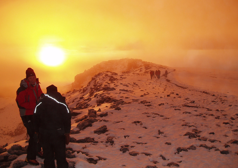
Today The ascent to Kilimanjaro is very popular with many hikers, especially those who start the assault on the “Seven Summits”. About 20 000 people cross the entrance to Kilimanjaro National Park each year and climb. The best time is from July to October or in January and February to avoid the rainy season. Park regulations impose hiking trails, means of climbing (guard, etc.) and entry fees. It is recommended to be accompanied by carriers and eventually a cook, but the law requires them to be accompanied by an authorized guide. All climbs require a good physical condition, especially to prevent the so-called “altitude sickness”. Although the risks are few, some tourists have lost their lives on the ascent, by accident or by lack of preparation; it is advisable to be cautious and to be informed before attempting the ascent, as only 40% of them are successfully completed. Guards are stationed on the mountain to allow rapid evacuation in case of emergency.
Access : Coordinates: -3.075833, 37.353333 / By plane :
Kilimanjaro International Airport is the nearest major airport with regular scheduled flights. It is the option for all passengers on Kilimanjaro. Condor flies once a week from Frankfurt and KLM flies several times a week from Amsterdam. From Kilimanjaro Airport there are still a number of good connections in the region, especially with Precision Air (Nairobi, Dar es Salaam, Mombasa, Zanzibar, Mwanza) and Air Tanzania (Dar es Salaam, Zanzibar). In addition to KLM, there are also other international airlines, such as: Ethiopian Airlines and Turkish Airlines to the airport. Ethiopian Airlines offers two daily connections to Addis Ababa in Ethiopia. / The national park is accessible by road.
Highlights :
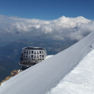
- National Park of the Kilimanjaro : The Kilimanjaro National Park, founded in 1973 and opened in 1977, includes the Kilimanjaro massif, which includes its tropical rainforests and the mountains Kibo, Mawenzi and Shira. The purpose of the approximately 756 km ² National Park is to protect the landscape and the flora and fauna of Mount Kilimanjaro and to preserve for the future. The park is located at 1800 to 5895 m above sea level. The annual rainfall varies from 2300 mm in the lower layers to 4600 mm in the higher mountain forest.
Hiking trails :
It takes six to ten days to reach the top and return. Kilimanjaro summit routes mainly use the southern slopes of the volcano, and some are very popular. The trails on the north side are reserved for experienced mountaineers. There are seven starting points (gates) around the mountain and various variants.
- Rongai route or Loitokitok route : This route is the most northern and starts at 1 950 m altitude. It is uncommon, well maintained, relatively easy and requires five to six days of ascent to travel its 45 km. It is favored during the rainy periods because it receives less precipitation. Camping is the only option for the first three nights. The second part of the route is equipped with shelters and offers a more direct variant that is farther from the Mawenzi. The final climb passes Gillman’s Point.
- Route Marangu Gate : The exit, from the door of Marangu, is located to the southeast of the mountain, at 1,870 m altitude in the heart of the jungle. It is the oldest, easiest and most regulated itinerary, but also the least spectacular and the most used by tourists with little experience and equipment needed. Four days of ascent and two days of descent are enough to travel its 36 km and it is possible to spend every night in a shelter. The final climb also passes through Gillman’s Point
- Mweka route : This route on the southern slope is the most direct, but also the most constant and dangerous. It is only used as a descent route. It approaches the Kibo summit near Stella Point and begins its 22 km from 1,640 m altitude along a ridge running through the southeastern valley.
- Umbwe route : This route is very uncommon and is also in the south of the Kibo. It opened in 1963. The route is short, steep and considered very difficult. The rapid ascent of 1,600 m altitude does not always allow the body to acclimate itself. From the final stretch of the Great Western Breach route, the climb is 31 km and requires five days of walking
- Machame route : It starts from the Machame Gate, which is southwest of the mountain at an altitude of 1,640m. The path goes through the Ravine, then between the Shira and the Kibo before reaching Lava Tower. This is one of the most spectacular routes and is becoming as popular as the Marangu route, however it does not offer many lodging opportunities and is relatively difficult due to its longer and higher treks, although the central part allows more. get acclimated. It takes six to seven days to reach the summit and 40 km of travel avoids the Great Western Breach
- Ruta Lemosho : Este itinerario de 49 km (polo Southern Circuit) no extremo oeste da montana e relativamente dificil e medianamente frecuentado. O panorama que ofrece do monte Meru, antes de pasar o Shira polo norte, e moi apreciado. Comeza a 2 360 m de altitude, na porta de Londorossi, e require entre seis e oito dias de ascension.
- Shira route : It is older and slightly further north than the previous route, on the western slope of the mountain. It starts at 3,600 meters altitude, much closer to the top, avoiding a long walk through the forest. It is still relatively difficult and fairly frequent because acclimatization is difficult in the early days. It takes six or seven days to travel its 34 km through the Southern Circuit
- Great Western Breach Route : This is the only alternative that allows access to the Uhuru from the west. Of course, it is accessible from the Shira – Lemosho – Machame route. Its passage allows you to cross an unevenness of 850 meters in just two kilometers, with the help of the hands. However, its slopes are unstable and resulted in the death of three climbers in January 2006. As a result of the accident, park officials decided to ban access for almost two years. Despite reopening in December 2007, this itinerary is strongly discouraged. In mountaineering the degree is assigned to him
- Southern Circuit or Summit Circuit route : This variant connects the Shira – Lemosho – Machame, Umbwe – Mweka and Marangu – Rongai routes south of the Kibo. It was the only way to reach the summit from the west at the end of the Great Western Breach route and has been recommended since. It has the advantage of offering a good view of the glacial front of the southern icefield (Southern Icefield) and then crosses the upper Karanga
- Northern Circuit Route : It is the most recent route and it is very busy. It is a variant that surrounds the Kibo from the northwest and links the Rongai route with the Shira – Lemosho – Machame route. It takes nine days to travel the 90 km to the top, avoiding the Great Western BreachClimbing :
The type of rock that predominates in these mountains is not very favorable for climbing. However, the peaks of the Mawenzi offer some good routes and the retreat of the Kibo glaciers contributes to the appearance of some vertical walls in some sections of the Umbwe route. You must obtain special permits before you start climbing - Breach Wall : Sometimes this wall is compared to the north face of the Eiger, and offers a difference in elevation from 4,700 to 5,400 m. The most natural direct route is called Messner and Renzler since these two climbers opened it on January 31, 1978; it runs, through frozen rocks and corridors, to the Balletto and Diamond Glaciers, and is listed as grade VI on the UIAA scale.
- Glaciar Kersten : As vias ao longo deste glaciar poden resultar dificiles de seguir debido ao relevo, a capa de neve e os desprendementos de pedras e xeo da tarde. Estan catalogadas de III+ a VI. A primeira ascension pola via orixinal foi realizada por Walter Welsch e Leo Herncarek entre o 20 e o 22 de setembro de 1962. A ruta polo lado dereito do glaciar foi realizada con exito por Mark Savage e Iain Allan o 28 e 29 de xullo de 1976. Finalmente, a via directa foi aberta os dias 20 e 21 de decembro de 1975 por Ian Howell, Bill O’Connor e John Cleare.
- Heim Glacier : This ride was first carried out by A. Nelson, H.-J. Cooke and D.-N. Goodall in 1957. It is listed as III +. The bottom can be slippery when the snow gives way to ice or rock. The upper part is dominated by the buttresses of the Window Buttress, where it is possible to mount a vivacity.
- Decken Glacier : The base of the glacier is narrow and inclined. Ice breaks and rocks may occur. It was first ascended on January 12, 1938 by E. Eisenmann and T. Schnackig, using the original route beginning at 4 650 m altitude. The first solo ascent on this route was by Ante Mahote in 1964. In August 1974, a path on the right side of the glacier was opened by M. Tudo, J. Montford, F. Schock, and J. Kuhn. Both routes are graded III / IV
- Little Penck Glacier : The trail follows snowfall from the bottom of the glacier at 4,900 to 5,700 m in elevation before the final Uhuru peak climb. It has been classified as III since the first ascent on June 20, 1969 by D. Payne and D. King
- Mawenzi : The summit offers two main routes that allow the Hans Meyer peak and the Nordecke to be connected. The first, cataloged II, takes a series of runners over the upper left of the North West Corrie to a rocky ridge. It was opened alone by R. F. Davies in January 1953.
Refuges :
The routes are equipped with unevenly distributed mountain shelters. The Marangu route has the most comfortable (linens, water, showers, electricity, kitchens). When there is no shelter, there are campsites at the end of each day of travel; many of these camps are located in caves. - Refuge Mawenzi Tarn : It is located at 4 315 m altitude on the Rongai route. It was built in the 1970s at the foot of a natural circus under the Mawenzi. It is being abandoned.
- Mandara refuge : This refuge is located at an altitude of 2,700 m on the Marangu route, after the first day of departure. Its construction dates from before the First World War. Bismarck, the name of the German imperial chancellor, was initially christened.
- Horombo Refuge : It is located at 3,720 m altitude on the Marangu route, and is the second of this itinerary. It has 120 beds distributed in several wooden cabins, a double capacity in relation to the other shelters located on this itinerary, because it serves both ascent and descent
- Refuge Kibo : This stone refuge is located at 4,703 m above sea level, after the crossing of the Marangu and Rongai routes. It has 60 beds.
- Mweka Refuge : It is located at 3,100 m altitude on the Mweka route, and was built in the 1960s. Unused for descent, and as ascension is prohibited it is in an advanced state of deterioration.
- Barafu Refuge : It is 4 673 m above sea level, after the crossing of the Mwake and Umbwe routes. It consists of the very basic shelters established in the 1960s, and where it is sometimes preferable to use the camp
- Moir shelter : This shelter is located at 4,200 m above sea level, after crossing the Lemosho, Shira and Machame routes.
- The city of Moshi, in the northeast of Tanzania on the southern slope of Kilimanjaro near the border with Kenya with a view of the mountain panorama.
- The Tsavo West National Park with its numerous large animal species, in Kenya only a few kilometers east of the Kilimanjaro National Park
- The Arusha National Park in the west of the Kilimanjaro National Park on the Tanzania side.
Activities : 5 days marangu route climbing mount kiimanjaro / 6 days umbwe route mount kilimanjaro trekking / sightseeing / photo opportunities / 7 days lemosho route mount kilimanjaro trekking / 7 days rongai route-mount kilimanjaro trekking.
Go next : the Amboseli National Park in southwestern Kenya / The Tsavo West National Park with its numerous large animal species, in Kenya / The Arusha National Park in the west of the Kilimanjaro National Park on the Tanzania side.