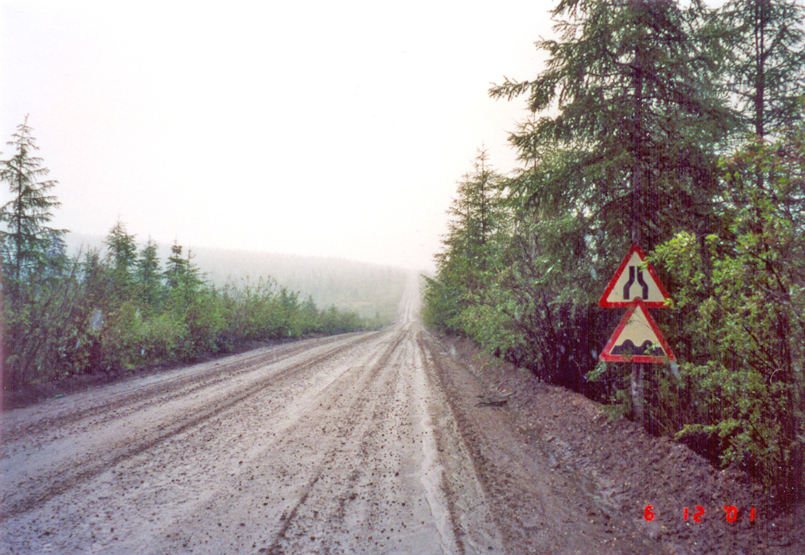
The R504 “Kolyma” or “Route of Bones” is an eastern Russian road that connects Magadan to Nizhny Bestiakh. It is 2,032 km long.
It was built under Stalin. The first part was built by the prisoners of the Sevvostlag labor camp in 1932. The work was continued by the prisoners of the neighboring Gulag camps until 1953.
The Kolyma highway is a key road in Russia’s Far East. It connects Yakutia with the Magadan region, provides access to the Pacific Ocean and is the only highway in the eastern parts of Yakutia and the western parts of the Magadan region. It is located in an area of extremely cold winters, and in some parts the average January temperatures are around -50 ° C.
The purpose of the route was to be able to bring prisoners to the Gulag camps, as well as to be able to transport the region’s resources, including gold and silver.
The road also has a historical name – the Kolyma highway, by which it is known in the literature and the media.The street is named after the Kolyma River, which it crosses at Debin. It used to be called the Street of Bones or the Street of Death, as many of the Gulag prisoners who were deployed were killed when it was built.
Today, most of the road has all-season coverage and is in relatively good condition. It is almost impossible to cross it in autumn or spring, as there is still no bridge over the Aldan River in the area of the village of Handiga. The condition of the Oymyakon road is extremely bad due to lack of maintenance. Sections of this road are regularly flooded by rivers in the summer, many bridges are broken – this makes it difficult to cross even with 4×4 jeeps. Today, it is used only by adventure motorcyclists as a challenge.
The ultimate adventure in the coniferous forests of the Russian Far East is ready to meet many mines, residents, wilderness, bears, squirrels, abandoned cities and other scenery.
Access : Coordinates: / There are several airports along the way ,in Yakutsk, Teyupliklyuch, Ustinola, Tomtor, Susuman and Sokol, as well as Yakutsk, Kandy and The river-sea port of Magadan. For a distance of 2025 kilometers, it takes 4 days to complete the journey. / West end : A360 A360 Lena Highway at Nizhny Bestyakh – East end : Magadan.
Highlights :
- Distances: Yakutsk 380 km> Khandyga 320 km> Kyubeme 405 km> Kadykchan 240 km> Ust Nera 378 km> Susuman 633 km> Magadan.
- The route : (** – ** designates an area that is not passable except when frozen). Yakutsk, along the Lena River 1. (** highway, 380 km northeast **, summer ferry across the Aldán River in Krest-Khaldzhan) 2. (Hydrofoil during the summer along the Lena and Aldán rivers, 530 km, 10 hours), Khandyga along the Aldán river, on the Suntar Khayatka mountains, 1200m pass over the Vostochnaya river. Kyubeme 1. (Old road) 155 km northeast towards Tomtor ** 250 km road northeast **, to Magadan Oblast) 2. (New route: ** winter road north 240 km to Ust-Nera along to the Indigirka river **, to the east: several mining towns, Artyk town, at the head of the Nera river, 1452m pass). Khadykchan (close to coal mines and the ancient Myaundzha uranium processing center). Susuman, Debin, Sinegorye with the Kolyma dam,
- Kolyma Highway connects the cities of Yakutsk and Magadan. The total length of the road is 2032 km, of which 1197 km fall in Yakutia, and 835 km – in the Magadan region.
- This area is extremely cold in winter. Two towns crossed by the road, Tomtor and Oimiakon, claim to be the coldest inhabited place on earth with temperatures around -70 ° C. On the surrounding plateaus, the temperature is around -80 ° C.
- Kadykchan is one of the most famous “ghost towns” in Russia,an abandoned city of miners.
- Via the old road, you can visit Tomtor and Oymyakon, the nearest cold towns in the Arctic (northern region). You can also travel from Susuman via Ustiomchug to Magadan, a large coal mining town. Approximately 70 kilometers via the road from Yagodnoye is Jack London Lake, which is rated as the highest fishing and scenic spot in the Russian Far East.
- The Highway of Bones has become a challenge for adventurous motorcyclists. After the fall of the Soviet Union, the road was traveled for the first time by western motorcyclists in the summer of 1995, by the British team Mondo Enduro (From west to east) and by the Norwegian traveler Helge Pedersen.
- the “Old Summer Road” and now completely left to the wilderness, is a great challenge for travelers who are crazy enough for such an adventure.
- Kolyma Highway was also crossed by bicycle in the winter of 2004 by Alastair Humphreys and Rob Lilwall, followed on foot by Rosie Swale-Pope in 2005 and crossed alone by motorcycle by Adrian Scott the same year.
This road is extremely dangerous during the winter , The darkest thing on the road that is considered cursed.
Activities : Tours on the Kolyma highway / Visit to the “Pole of Cold” – Oymyakon, the coldest settlement on earth.
Go next : visit Tomtor and Oimyakon, the nearest towns to the ,northern – Pole of Cold, Tomtor and Oymyakon, proclaim themselves the coldest inhabited place on Earth, reaching -71.2 ° C / Yakutia, also known as the Republic of Sakha, is located in the Russian Far East / The Anadyr Highway.