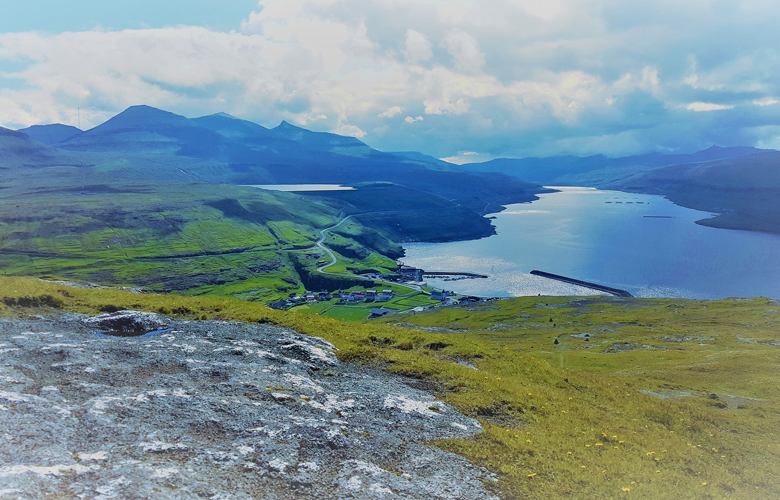
Eysturoy ( meaning is ” The Eastern Island ” ) is the second largest island in the Faroe Islands archipelago (Denmark), located in the Norwegian Sea. With an extension of 286.3 km² and a population of 10,586 inhabitants, it is separated by a small strait of the island of Streymoy, the largest in the region.
The island of Eysturoy is extremely mountainous, with around 66 isolated peaks, among which is Slættaratindur, the highest point of all the Faroes.
The island of Eysturoy is extremely mountainous, with around 66 isolated peaks, among which is Slættaratindur, the highest point of all the Faroes.
Its coast has several long fjords, most notably the Skálafjørður in the south of the island, which is the largest in the archipelago.The most important cities of Eysturoy are Fuglafjørður in the north, and the densely populated area of Runavik and Nes municipalities in the south.
Over the strey that connects it to Streymoy is the so-called “only bridge over the Atlantic Ocean,” as the locals humorously designate.
Runavik port now has a second use as a ferry port: when large passenger boats such as the Norrona cannot dock at Torshavn, they travel to the port of Runavik.
Runavik port now has a second use as a ferry port: when large passenger boats such as the Norrona cannot dock at Torshavn, they travel to the port of Runavik.
Towns and Villages : Gjógv , Eiði , Funningur , Elduvík , Æðuvík , Oyndarfjøðrur, Fuglafjørður , Leirvík , Syðrugøta , Gøtugjógv , Norðagøta , Nes , Runavík , Toftir , Strendur , Selatrað ,
Access : Coordinates: 62.216667, -6.883333 / Eysturoy is in the center of the Faroes, and is connected with Streymoy via a road bridge over the sound./ is possible to reach the island with either public bus or ferry. The inter-town bus system , takes in all settlements./Buses connect Torshavn with Gota, and Gota with the rest of Eysturoy.
Highlights :
- Eiði : with a picturesque location in a dramatic landscape, In the middle of the village is a local museum in a renovated older traditional Faroese farmhouse with smokehouse Roykstova.
- Gjogv, one of the most popular photo opportunities through his small natural harbor in a crevice. Gjogv is best known for the natural harbor with the ferry boats sailing right into the bottom of the gorge, after which they are pulled up via a ramp so that they are protected, free of the waves.The village is close to Slættaratindur, the highest peak on the Faroes.
- Gota with the museum Blasastova and the thermal spring of Fuglafjørður (varmakelda), which testifies to the volcanic origin of the archipelago.
Between Eiði and Gjogv / Funningur a steep pass road leads over the 392 m high , which is located directly below the Slættaratindur, with 882 m the highest mountain in the Faroe Islands. - Elduvik has a unique view of Kalsoy. One to divide the picturesque old village into two boroughs with each its own small landing site. The black tarred wooden houses with foundations of masonry natural stone are closely assembled in two clusters on both sides of the small creek.
- Oyndarfjordur is one of the oldest Faroese villages. At the beach below the village are the two Rinkusteinarnir (rock stones) which are set in motion by the waves.
- Fuglafjørður spreads over a valley lowering a bay and up the surrounding mountain sides. At the beach edge on the south side of the fjord by the mountain road to Leirvik there is a hot spring called “Varmakelda”.
- Leirvik is surrounded by high mountains and the Northern Isles. Near the picturesque fishing port is the Viking ruins on the Toftanesi, with the remains of a 1000 year old Viking farm. The village has its own museum with the old ferry boats.
- The old mountain road from Leirvik to Kambsdalur has a unique view of Kalsoy, Kunoy and Bor∂oy . All the way back to the Viking Age, there has been a warpath over the mountains to Norðagøta.
- Norðagøta together with Syðrugøta and Gotugjogv form the area Gota at the bottom of the wide Gotuvik fjord. At this historic site lived the famous Viking chief, Trondur i Gotu. Ruins of his farm are found in Gota. At the Blasastova regional museum, there is an exhibition on the culture and daily life of the Faroe Islands in recent centuries.
- Runavik is one of many settlements that eventually form a 10 km long settlement on the eastern side of Skálafjørður . Runavik has tourist information, a hotel, a restaurant and a campground that is open all year.
- the village of Nes with its old wooden church and historic rectory. – Glyvrar is an old peasant village, which was first mentioned in writing 1584, but may be older. Near the church is the interesting little museum , which is open in the summer.
- Slættaratindur (882 m) – the highest mouantain in the Faroe Islands / The Varmakelda – The thermal springs south of Fuglafjørður – Blasastova – historical museum in Norðagøta / a heritage museum in Eiði
- The Eysturoy tunnel : The Eysturoy tunnel connects Skálafjørður and Torshavn together with a subsea tunnel, which will be a full 11 kilometres long.
- the tiny village of Gjovn. It has about 50 inhabitants, a church by the sea and the traditional houses with grass roofs. At one end of the Ambadalur valley, to the north on the island of Eysturoy.
- La Gorga, nickname for which the gorge is known, constitutes a spectacular natural landscape. It is one of the best known attractions in the Faroes.a small beautiful natural port in a rock column at Gjogv
- Búgvin is a 188 meter freestanding cliff with rich bird life. / hanging valleays on the route to Oyndarfjøðrur./ The Lake of Toftavatn / In Fuglafjordur there is a small dark sandy beach.
- Funningur, (60 inhabitants) which is the first Viking settlement in the Faroe Islands. It was Grimur Kamban, who escaped the tyranny of the Norwegian king Harald I. The fjord that bears his name.In the village is a typical Faroese wooden church from 1847.
- Bird Area : The north, north-east, and south-east coasts of the island have been identified as an Important Bird Area by BirdLife International.
- Glyvrar is an old peasant village, which was first mentioned in writing 1584, but may be older
- Road 632 continues west past Eiði and parallel to the strait between Eysturoy and Streymoy to the Eysturoy bridge. The road is known as one of the most beautiful panoramic roads in the Faroe Islands.
Activities : Discover the small coastal towns hidden between fjords./ Small Group Excursions / Road trips : Experience the most amazing thing ever whilst driving above the fog, ‘Heaven on Earth’.
Go next : Streymoy / Island of Kalsoy / the tiny village of Trollanes / the lighthouse of Kallur / the small village of Mikladalur, a place that contains the best known of the legends in the Faroe Islands. / the legendary islets of Risin and Kellingin / Torshavn /