


The Cape Peninsula is in Western Cape of South Africa,
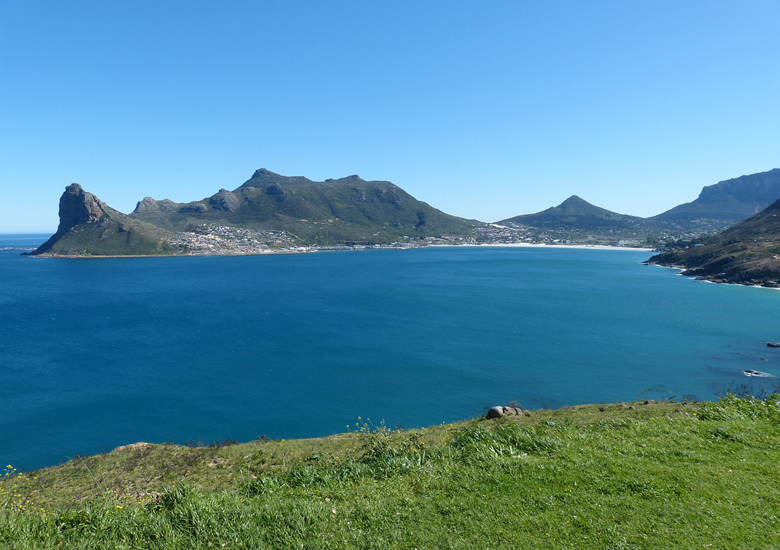
The Cape Peninsula is a generally rocky peninsula that juts out into the Atlantic Ocean at the south-western extremity of the African continent. At the southern end of the peninsula are Cape Point and the Cape of Good Hope. On the northern end is Table Mountain, overlooking Cape Town, South Africa. The peninsula is 52 km long from Mouille point in the north to Cape Point in the south.
The Peninsula has been an island on and off for the past 5 million years, as sea levels fell and rose with the ice age and interglacial global warming cycles of, particularly, the Pleistocene. The last time that the Peninsula was an island was about 1.5 million years ago. Soon afterwards it was joined to the mainland by the emergence from the sea of the sandy area now known as the Cape Flats. The towns and villages of the Cape Peninsula and Cape Flats now form part of the City of Cape Town Metropolitan Municipality.
The Cape of Good Hope is sometimes given as the meeting point of the Atlantic and Indian Oceans. Thus the west coast of the Peninsula is invariably referred to as the “Atlantic Coast”, but the eastern side is known as the “False Bay Coast”. It is at Cape Point (or the Cape of Good Hope) that the ocean to the south is often said to be divided into the Atlantic Ocean to the west, and the Indian Ocean to the east. However, according to the International Hydrographic Organization agreement that defines the ocean boundaries, the meeting point is at Cape Agulhas, about 200 km (120 mi) to the southeast
Similarly, Cape Point is not the fixed “meeting point” of the cold Benguela Current, running northwards along the west coast of Africa, and the warm Agulhas Current, running south from the equator along the east coast of Africa. In fact the south flowing Agulhas Current swings away from the African coastline between about East London and Port Elizabeth,
from where it follows the edge of the Continental shelf roughly as far as the southern tip of the Agulhas Bank, 250 km (155 miles) south of Cape Agulhas.From there it is retroflexed (turned sharply round) in an easterly direction by the South Atlantic, South Indian and Southern Ocean currents, known as the “West Wind Drift”, which flow eastwards round Antarctica. The Benguela Current, on the other hand, is an upwelling current which brings cold, mineral-rich water from the depths of the Atlantic Ocean to the surface along the west coast of Southern Africa. Having reached the surface it flows northwards as a result of the prevailing wind and Coriolis forces. The Benguela Current, therefore, effectively starts at Cape Point, and flows northwards from there, although further out to sea it is joined by surface water that has crossed the South Atlantic from South America as part of the South Atlantic Gyre. Thus the Benguela and Agulhas currents do not strictly “meet” anywhere, although eddies from the Agulhas current do from time to time round the Cape to join the Benguela Current.
Regions : Blaauwberg Coast , The coastline region north of Cape Town
Atlantic Seaboard / The coastline region south of Cape Town ,
False Bay / The south & eastern side of the peninsula and the coast up to Gordon’s Bay Cities : Cape Town , Other destinations : Table Mountain National Park
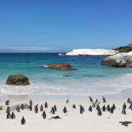
, Robben Island. Attractions : Boulders is a popular beach near Simon’s Town
Access : Coordinates: -34.205, 18.404 / By plane : Cape Town International Airport . Go to Cape Town, visit the Cape Winelands, drive up to the north along the West Coast or to the east onto the Garden Route.
Get around : By train : Train service is only available between Simon’s Town and Cape Town and won’t bring you to the Cape of Good Hope, so the best option is a car. Another option is one of the tours offered everywhere in Cape Town.
By car : Take the roads from Cape Town southward, passing Simon’s Town and the Boulders to go to the Cape of Good Hope. You will always be on the peninsula, when you are south from Table Mountain. The Table Mountain National Park offers visitors some indigenous vegetation and stunning views at Cape Point.
Activities : Dive the waters of Cape Town on the Atlantic or False Bay coastline of the Peninsula . Chapman’s Peak Drive : Drive the scenic drives along the east and west coast of the Peninsula. Chapman’s Peak Drive is one of the most spectacular coastal roads in the world. It begins in Hout Bay on the west coast of the peninsula and ends 9 km later in Noordhoek. It is a toll road.
Visit the Cape of Good Hope and Cape Point in the Table Mountain National Park.
Take a look at the penguins at Boulders Beach.
Swim, surf and paddleski in the warm water and safe beaches at Muizenberg, Fish Hoek and Simon’s Town on the east coast of the peninsula.
Walk for miles along the beaches of Hout Bay, Noordhoek and Kommetjie on the west coast of the peninsula. The water on this side is very cold, so you’ll need a wetsuit if you want to surf. Suntan and people-watch on the trendy beaches of Camps Bay, Clifton and Llandudno. Visit Victoria & Alfred Waterfront
Go next : Go to Cape Town, visit the fish hoek , Cape Winelands, drive up to the north along the West Coast or to the east onto the Garden Route.

![By Derek Keats (Flickr: Elsie's Peak) [CC BY 2.0 (https://creativecommons.org/licenses/by/2.0)], via Wikimedia Commons](https://www.thewanders.eu/wp-content/uploads/2018/10/Fish_Hoek_from_Elsies_Peak-190x190.jpg)