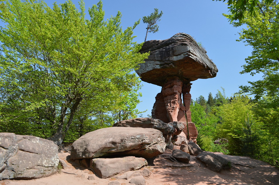
The Devil’s Table (German: Teufelstisch) in Hinterweidenthal is a 14 metre high mushroom rock in the German part of the Wasgau region, the southern Palatine Forest in the state of Rhineland-Palatinate) – Germany.
Thanks to its location in the territory of the village of Kaltenbach – formerly part of Wilgartswiesen – it is often called the Kaltenbach Devil’s Table (Kaltenbacher Teufelstisch), especially in old literary sources. It is larger and better known than the Devil’s Table of Salzwoog, which is only 5 kilometres away to the southwest.
The Hinterweidenthal Devil’s Table is one of the landscape symbols of the Palatinate and is also the subject of a local legend. In 1947 the rock was portrayed on a Rhineland-Palatinate postage stamp.
Geography : The Devil’s Table stands a few hundred metres south of the B 10 road and west of Hinterweidenthal-Kaltenbach on a 312-metre-high ridge, which runs for over two kilometres from Etschberg in the southwest to the 324-metre-high Handschuh-Kopf in the northeast. The rock towers prominently over the surrounding woods. At night it is lit from the northern side, so that it can be seen from the B 10.
Access : Coordinates: 49.194903, 7.743761 / From Kaiserslautern- Ramstein you can take Autobahn 6 to Kreuz Landstuhl West onto Autobahn 62, direction Pirmasens. Leave the autobahn at exit 15/Pirmasens and follow Highway 10 to Unterweidenthal. Follow the sign “Teufelstisch” (Devil’s Table) for public parking. Marked footpaths lead to the monument — a five-minute walk. Location : Im Handschuhteich 29, 66999 Hinterweidenthal, Germany. Hours: All days 10AM–6PM /
Go next : At the foot of the hill on which the Devil’s Table stands, is a car park, an inn and the Devil’s Table Adventure Park.