
TL;DR: Alta Via del Sale: Ligurian Alps trekking guide, The Alta Via del Sale (High Salt Road) is a breathtaking ridge route connecting Liguria and Piedmont in Italy’s Western Alps. Running roughly 70km from Limone Piemonte to Monesi di Triora at elevations between 1,800-2,600m, this historic military and trade route offers jaw-dropping Mediterranean views, accessible 4×4 trails, challenging mountain bike routes, and unforgettable hiking. Best visited June-October, it’s perfect for adventurers seeking an off-the-beaten-path Alpine experience without the crowds of more famous routes.
- Why You Need the Alta Via del Sale on Your Bucket List
- What Makes This Route So Special?
- Planning Your Alta Via del Sale Adventure
- The Route Breakdown: What to Expect
- Different Ways to Experience the Alta Via del Sale
- The Weekend Warrior 4×4 Adventure
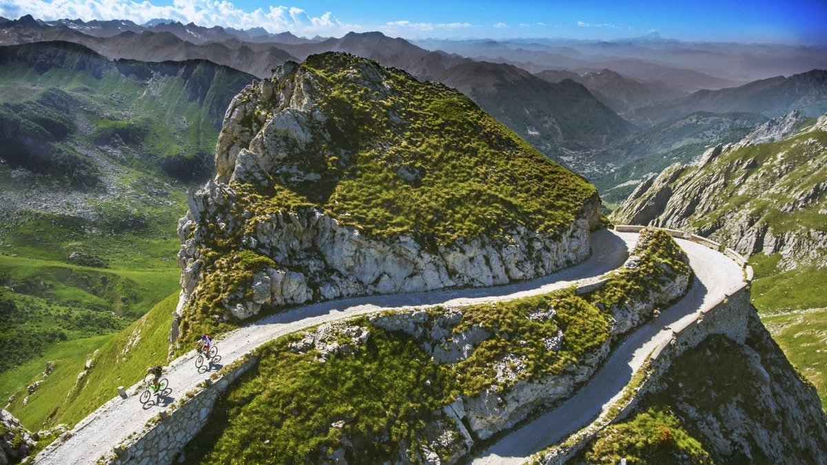
- The Mountain Biker’s Challenge
- The Trekker’s Multi-Day Journey
- The Day-Tripper’s Sampler
- Local Culture and History Worth Knowing
- Safety and Practical Considerations
- What to Eat (Because Food Matters)
- Nearby Attractions to Extend Your Trip
- Sustainable Travel Tips
- The Bottom Line
- Quick Recap
Why You Need the Alta Via del Sale on Your Bucket List
Let’s be real—you’ve probably scrolled past a thousand photos of the Dolomites and Mont Blanc. But the Alta Via del Sale? This is Italy’s best-kept Alpine secret, and honestly, it might just ruin other mountain drives for you.
Situated along the ridge between the Maritime Alps and the Ligurian Sea, this legendary route delivers what most mountain roads only promise: panoramic views that’ll have you pulling over every five minutes, historic trails that actually have stories to tell, and that rare feeling of discovering somewhere truly special before everyone else does.
What Makes This Route So Special?
The Views Are Absolutely Unreal
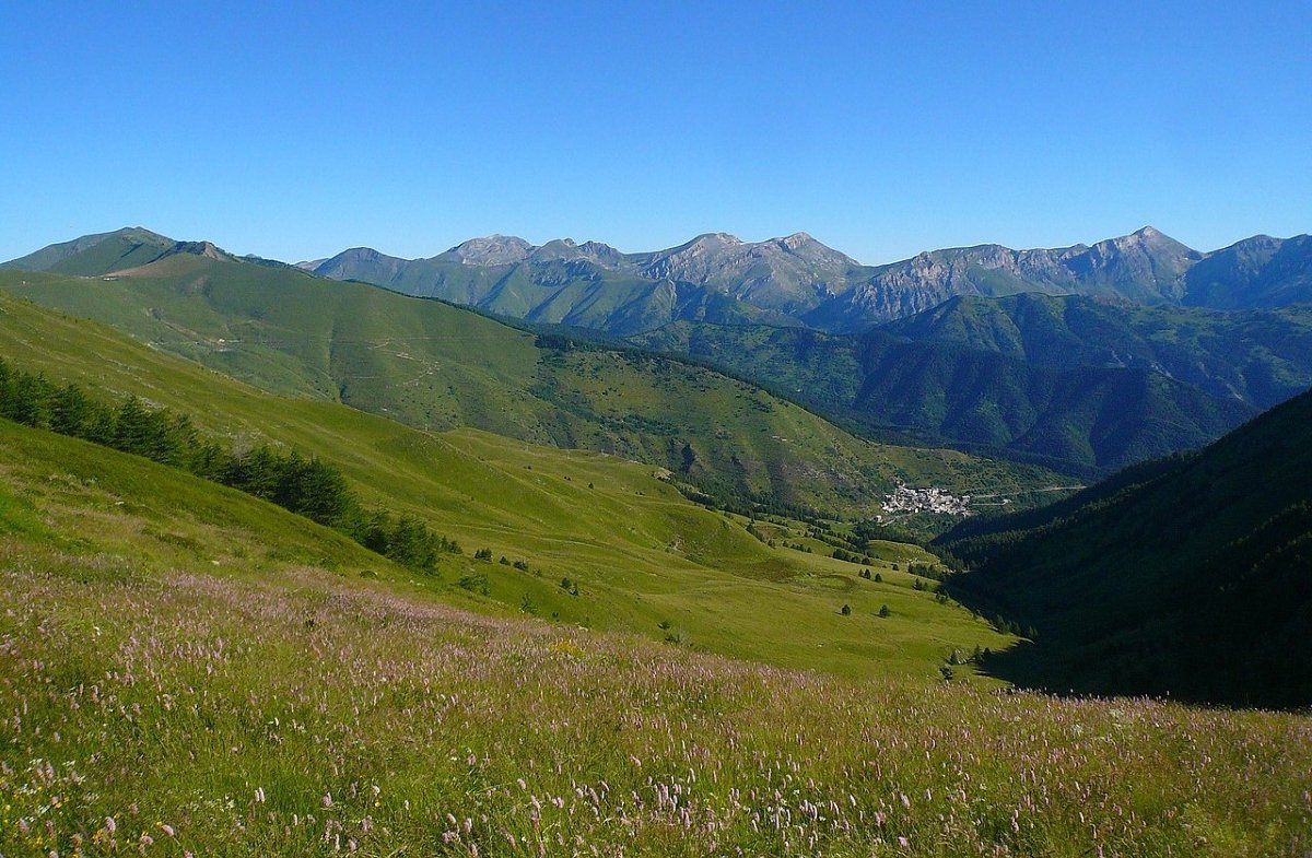
Picture this: you’re standing at 2,000+ meters, with the Mediterranean sparkling on one side and the snow-capped Alps stretching endlessly on the other. On clear days, you can see Corsica. Yeah, you read that right—an island 200km away. The Alta Via del Sale delivers this kind of perspective on the regular.
The route follows ancient ridgelines where salt traders once hauled their precious cargo from the coast to Piedmont’s interior. These days, instead of mules carrying salt, you’ve got mountain bikers, 4×4 enthusiasts, and hikers following the same dramatic paths.
It’s Way More Accessible Than You’d Think
Unlike some Alpine routes that require serious mountaineering skills, the Alta Via del Sale welcomes everyone from casual hikers to hardcore adventurers. You can tackle it by:
- 4×4 or SUV: The main route is a maintained dirt road perfect for capable vehicles (summer months only)
- Mountain bike: Increasingly popular, with sections ranging from flowy gravel to technical singletrack
- Hiking: Multiple access points let you choose day hikes or multi-day trekking adventures
- Motorcycle: Adventure bikes handle the route beautifully (check current conditions first)
Planning Your Alta Via del Sale Adventure
When to Go
Best months: Late June through September
Why these months: The route typically stays snowbound until mid-June. By late June, most passes open and wildflowers carpet the meadows. July and August bring stable weather and maximum accessibility, though expect more company on weekends. September offers stunning fall colors and fewer crowds—it’s honestly the sweet spot if you can swing it.
Avoid: October through May unless you’re on a winter mountaineering expedition. Seriously, the passes get buried under meters of snow.
Getting There
Main access points:
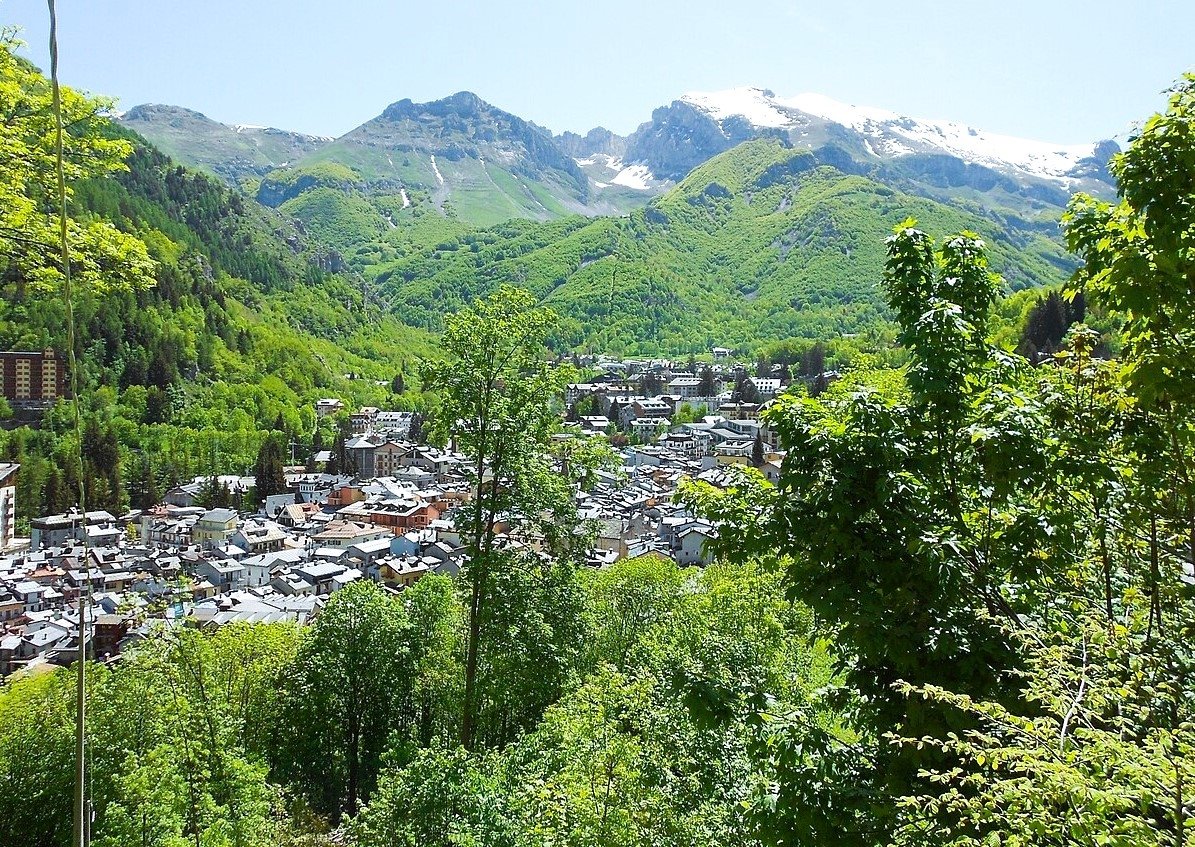
From the coast (west): Monesi di Triora in Liguria is your starting point if you’re coming from the Mediterranean side. Drive up from Triora, a gorgeous medieval village worth exploring on its own.
From Piedmont (east): Limone Piemonte serves as the eastern gateway. This ski resort town has all the amenities you need and makes an excellent base.
Pro tip: Consider doing a one-way journey with a car shuttle or ride-share back to your starting point. The full traverse typically takes 6-8 hours by vehicle (longer with photo stops—and trust us, there will be many).
What You’ll Need
For drivers:
- 4×4 or high-clearance SUV (seriously, don’t attempt this in your rental Fiat 500)
- Updated GPS/maps (cell service is spotty)
- Full tank of gas—no services along the route
- Emergency supplies (water, snacks, basic tools, first aid kit)
- Cash for any refuge stops
For bikers and hikers:
- Proper navigation tools (GPS device or downloaded offline maps)
- Layered clothing (weather changes fast at altitude)
- Sun protection (the UV is intense up there)
- Plenty of water and high-energy snacks
- Emergency blanket and whistle
- Charged phone with emergency numbers saved
The Route Breakdown: What to Expect
Key Highlights You Can’t Miss
Colle della Melosa (1,548m) Your introduction to the route’s magic. The transition from forested valleys to open ridgelines happens here, and the views start getting seriously good.
Colle di Tenda (1,871m) Historical significance meets stunning scenery. This pass has been a crucial crossing point for millennia. The old Fort Centrale stands as a reminder of the area’s strategic importance.
Lago delle Portette This alpine lake offers the perfect excuse for a break. The reflection of surrounding peaks in its crystal waters is Instagram gold (though you might not have signal to post it immediately).
Marguareis Massif Views At 2,651m, Monte Marguareis dominates the skyline. Even if you’re not summiting, the views of this limestone giant are spectacular from various points along the Alta Via.
Cima Marta (2,130m) Many consider this the route’s visual climax. From here, you genuinely feel suspended between sea and mountains—the Ligurian coast spreads out below while Alpine peaks surround you.
Refuges and Places to Stay
Rifugio Mondovì Havis de Giorgio (2,050m) Perfectly positioned for multi-day adventures. The food is hearty, the hosts are welcoming, and waking up above the clouds is unforgettable. Book ahead during peak season.
Rifugio Allavena (1,700m) Smaller and more intimate, this refuge offers genuine Alpine hospitality. Their polenta is legendary among regular visitors.
Rifugio Don Barbera (1,750m) Family-run with a cozy atmosphere. Great option if you’re trekking with less experienced adventurers or families.
Important: Many refuges operate only during summer months and require reservations. Wild camping is restricted in some areas—always check local regulations.
Different Ways to Experience the Alta Via del Sale
The Weekend Warrior 4×4 Adventure
Time needed: 2 days
Spend day one driving the route with plenty of stops for photos and short walks. Camp or stay at a refuge overnight, then explore side valleys and trails on day two before heading back. This gives you the full experience without rushing.
The Mountain Biker’s Challenge
Time needed: 2-4 days depending on fitness level
The Alta Via del Sale is gaining serious cred in the mountain biking community. The terrain varies from flowing gravel roads to technical rocky sections. Most riders split it into two or three days, staying at refuges to avoid carrying camping gear.
Difficulty: Intermediate to advanced. You’ll face sustained climbs, loose descents, and exposed sections. E-bikes are becoming popular here (no shame in the assist game at these elevations).
The Trekker’s Multi-Day Journey
Time needed: 4-6 days
Hiking the full route lets you experience the landscape’s subtle shifts at the perfect pace. Link refuges for supported trekking, or go backcountry with proper camping gear. The trail offers variations in difficulty—research your specific route based on your fitness level.
The Day-Tripper’s Sampler
Time needed: 5-8 hours
Short on time? Pick a section! The stretch from Colle di Tenda to Marguareis offers maximum scenery for minimum time investment. Or drive to Cima Marta for a shorter hike with massive payoff views.
Local Culture and History Worth Knowing
The Salt Trade Legacy
For centuries, this route served as a vital economic artery. Salt from coastal lagoons traveled these ridges to Piedmont, where it was precious as gold for preserving food. Traders braved avalanches, bandits, and brutal weather to keep commerce flowing. The modern route follows many of these ancient paths—you’re literally following in the footsteps of history.
Military Heritage
During WWII and the Cold War, these mountains bristled with fortifications. Italy’s Alpine Wall (Vallo Alpino) included numerous bunkers and defensive positions you’ll spot along the route. Some are accessible for exploration—just be careful and respectful.
The Villages Below
Don’t skip the valley towns. Triora has earned the nickname “the Salem of Italy” for its witch trial history—it’s fascinating and genuinely atmospheric. Limone Piemonte blends ski culture with traditional mountain life. Venture down to these communities for authentic Ligurian and Piedmontese cuisine that’ll fuel your next adventure.
Safety and Practical Considerations
Weather: Respect It or Regret It
Alpine weather changes faster than you can swipe through Instagram stories. Morning sunshine can turn into afternoon thunderstorms without warning. Always check forecasts before heading out, and be prepared to turn back if conditions deteriorate.
Red flags to watch for:
- Rapidly building clouds (especially dark ones from the coast)
- Sudden temperature drops
- Increasing wind
- Any lightning—get off ridges immediately
Navigation Essentials
GPS is great until it’s not. Carry physical maps as backup. The route is generally well-marked, but fog can roll in and disorient even experienced navigators. Download offline maps before you go—apps like Maps.me or specific cycling/hiking apps work well.
Emergency Preparedness
Cell coverage is unreliable at best. Save emergency numbers before you lose signal:
- Mountain rescue (CNSAS): 118
- General emergency: 112
Tell someone your plans before heading out. Not to be dramatic, but mountain rescues happen, and they go much smoother when someone knows where to look for you.
What to Eat (Because Food Matters)
At the Refuges
Alpine refuges serve hearty, no-nonsense mountain food. Expect polenta dishes, local cheese (toma is divine), salamis, and homemade pasta. Portions are generous—you’ll need the calories. Refuge food isn’t fancy, but it’s honest, delicious, and hits differently when you’re exhausted and starving at 2,000m.
Pack These Snacks
- Energy bars (more than you think you need)
- Dried fruits and nuts
- Salami or cured meat (very Italian, very practical)
- Dark chocolate (quick energy plus morale boost)
- Electrolyte supplements for your water
Down in the Valleys
After your adventure, hit the local towns for proper Ligurian cuisine. Farinata (chickpea pancake), focaccia, fresh pesto, and local wines will taste especially good after days of trail rations. Trust us on this.
Nearby Attractions to Extend Your Trip
Cuneo: This elegant Piedmontese city makes an excellent base with real restaurants, comfortable hotels, and culture.
The Ligurian Coast: You’re tantalizingly close to the Mediterranean. Sanremo is less than an hour’s drive—coastal glamour after mountain ruggedness feels surreal.
Parco Naturale Alpi Marittime: If you’re hungry for more trails, this protected park offers excellent hiking with slightly less challenging terrain.
Via Ferrata Routes: The region has numerous via ferrata (protected climbing routes) for those seeking an adrenaline bump.
Sustainable Travel Tips
This landscape is stunning because it’s been preserved. Help keep it that way:
- Pack out everything you pack in—seriously, everything
- Stay on marked trails (erosion is a real problem)
- Respect wildlife (chamois, ibex, and marmots call this home)
- Support local refuges and businesses rather than just doing day trips
- Use designated camping areas only
- Keep noise levels reasonable (mountain silence is part of the experience)
The Bottom Line
The Alta Via del Sale isn’t trying to compete with the Alps’ greatest hits. It doesn’t need to. This route offers something increasingly rare: a genuine sense of discovery. You’ll find challenging terrain without death-defying exposure, stunning views without elbow-to-elbow crowds, and a landscape where history and natural beauty intertwine seamlessly.
Whether you’re gripping the wheel of a 4×4, grinding up climbs on your mountain bike, or setting a steady hiking pace with a pack on your back, the Alta Via del Sale delivers an experience that’ll stick with you long after you’ve descended back to sea level.
Your Mission: Check the weather forecast. Pack your gear. Point your vehicle (or boots, or bike) toward the Ligurian Alps. And prepare for one of Italy’s most underrated adventures to absolutely blow your mind.
Quick Recap
What: 70km high-altitude route through the Maritime Alps between Liguria and Piedmont
When: Late June through September (July-August for guaranteed access)
Who: Anyone with decent fitness and proper equipment—families to hardcore adventurers
How: 4×4 driving, mountain biking, hiking, or adventure motorcycling
Why: Unmatched views, historical significance, fewer crowds, and that rare feeling of discovering somewhere truly special
Budget: €50-100/day (refuges, food, fuel) to €200+/day (guided tours, nicer accommodations)
Disclaimer: Mountain conditions change rapidly and unpredictably. This guide provides general information based on typical conditions, but always check current weather, road status, and local advisories before attempting the Alta Via del Sale. Requirements for vehicles, equipment, and permits can change—verify everything with local authorities or tourism offices before your trip. The author and publisher assume no responsibility for accidents, injuries, or mishaps occurring during your adventure. Mountain travel involves inherent risks—assess your abilities honestly and don’t hesitate to turn back if conditions exceed your skill level. When in doubt, hire a local guide who knows the terrain and current conditions.


 is a breathtaking ridge route connecting Italy's Western Alps.)