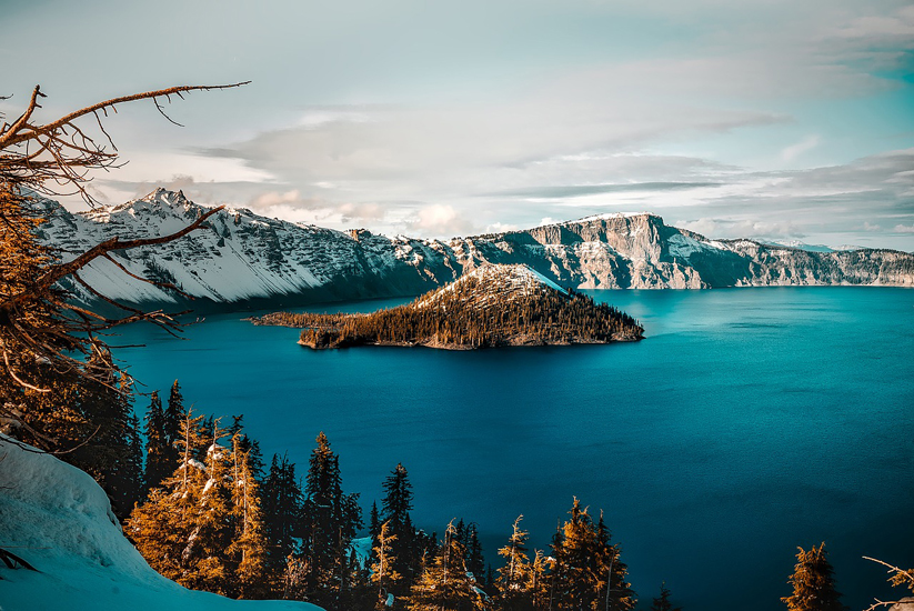
Crater Lake National Park is a United States national park located in southern Oregon, in the United States. The centerpiece of the park is Crater Lake, the deepest lake in the United States, known for its deep blue color.
Understand : Dogs and other pets are not allowed on park trails. Smoking is not allowed on any trail. Bicycling is permitted only on paved roads and the Grayback Drive.
Feeding wild animals, including birds, is prohibited. Feeding animals is dangerous for you, bad for them, and harmful for the ecosystem.
Stay on trails to protect vegetation and fragile hillsides. Shortcutting trails, particularly on switchbacks, can damage slopes, making them more susceptible to erosion and visual damage.
Hiking on the caldera rim around the collapsed volcano is extremely dangerous and prohibited. People have fallen to their deaths not only by slips and falls, but from unexpected rock slides underfoot.
Be prepared , equip yourself with water, food, warm clothing, rain gear, and anything else appropriate to the trail you take. It is better to be over-prepared than under-prepared.
Leave all rocks, plants and artifacts undisturbed for the enjoyment of future visitors.
Do not drink water from park streams or from the lake without properly treating it.
Hunting is not permitted in Crater Lake National Park.
History : Crater Lake was formed from the collapse of Mount Mazama, a volcano in southern Oregon that once stood about 11,000 feet (3,353 m) tall. A series of destructive eruptions around 5000 BC caused the mountain’s peak to collapse into its lava chamber, resulting in a caldera nearly 6 miles (9.7 km) wide. Over time, snowmelt and rain collected in the crater to form the lake, which at 1,949 feet (594 m) deep, is the deepest in the USA, 2nd in North America, and 9th in the world. Based on a comparison of average depths, however, Crater Lake at 1148 feet (350 m), is the deepest in the Western Hemisphere and third deepest in the world. The first known white man to reach the lake was prospector John Hillman, who found the lake in 1853. Largely through the efforts of naturalist William Gladstone Steel, the United States declared Crater Lake a national park in 1902. Climate : Crater Lake’s location high in the Cascade mountains (about 6,000 feet/1,830 m above sea level) means that snow is often visible year-round. The lake is often enveloped in heavy snow during the fall, winter, and spring, forcing the closure of roads and trails. In fact, the lake averages 533 inches (1,353 cm) of snow a year. Consequently, the best time to visit Crater Lake is in the summer months, when all facilities, roads, and trails are open.
Access : Coordinates: 42.95, -122.1 / By plane : The nearest major airport to Crater Lake National Park is Rogue Valley International-Medford Airport, located three miles (4.8 km) north of Medford and 80 miles (129 km) south of the park. By car : From the north : From Eugene, Portland, and points north on I-5: Follow Interstate 5 south to Roseburg, then take Oregon 138 east to the park’s north entrance.
From Bend and Central Oregon: Follow U.S. 97 south to Oregon 138 west to the park’s north entrance. The north entrance is typically closed for the winter season (mid-October to mid-June). From the south : From Medford and points south on I-5: Follow Interstate 5 north to Medford, then take Oregon 62 north and east to the park’s west entrance (open year round). From Klamath Falls: Follow U.S. 97 north to route 62 north and west to the park’s south entrance (open year round).By foot : The Pacific Crest Trail (PCT) is a well known trail that extends along the West coast of the United States, from Mexico to Canada. It passes through California, Oregon, and Washington State
Fees and permits : The entry fee for cars is $10 for seven days. Motorcycles, bicycles, and pedestrians are $5 per person for seven days. There are several passes for groups traveling together in a private vehicle or individuals on foot or on bike. These passes provide free entry at national parks and national wildlife refuges, and also cover standard amenity fees at national forests and grasslands, and at lands managed by the Bureau of Land Management and Bureau of Reclamation. These passes are valid at all national parks including Crater Lake National Park:
The $80 Annual Pass (valid for twelve months from date of issue) can be purchased by anyone. Military personnel can obtain a free annual pass in person at a federal recreation site by showing a Common Access Card (CAC) or Military ID.
U.S. citizens or permanent residents age 62 or over can obtain a Senior Pass (valid for the life of the holder) in person at a federal recreation site for $80, or through the mail for $90; applicants must provide documentation of citizenship and age. This pass also provides a fifty percent discount on some park amenities. Seniors can also obtain a $20 annual pass.
U.S. citizens or permanent residents with permanent disabilities can obtain an Access Pass (valid for the life of the holder) in person at a federal recreation site at no charge, or through the mail for $10 applicants must provide documentation of citizenship and permanent disability. This pass also provides a fifty percent discount on some park amenities.
Individuals who have volunteered 250 or more hours with federal agencies that participate in the Interagency Pass Program can receive a free Volunteer Pass.
4th graders can receive an Annual 4th Grade Pass that allows free entry for the duration of the 4th grade school year (September-August) to the bearer and any accompanying passengers in a private non-commercial vehicle. Registration at the Every Kid in a Park website is required.
In 2018 the National Park Service will offer four days on which entry is free for all national parks: January 15 (Martin Luther King Jr. Day), April 21 (1st Day of NPS Week), September 22 (National Public Lands Day), and November 11 (Veterans Day weekend).
Get around : The 33-mile (53 km) Rim Drive encircles Crater Lake, giving varied perspectives of the lake, rim, and surrounding terrain. Open only during the summer from late June to mid-October, there are many overlooks with interpretive signs. The only access to the lake itself is by steep trail to Cleetwood Cove, where boat tours of the lake are offered. Numerous picnic areas are along the Rim Drive, as is hiking access from Rim Village to Garfield Peak. Rim Drive also accesses Lightning Springs (west side), Cleetwood Cove (north side), Mount Scott (east side), Sun Notch Viewpoint and Crater Peak (south side). Both Kerr Notch and Sun Notch Viewpoints are particularly spectacular viewpoints, with views down to Phantom Rock and across the lake to Wizard Island. There are many trails open to horses. But, if you’re not a cowboy then hiking the trails is also a great experience. While on the trails keep an eye open for the many deer grazing in the hills
Highlights :
- The Pinnacles, End of Pinnacles Rd.. Can be reached in the summer from the Rim Drive on a paved, 6-mile (9.6 km) road. These eerie spires of eroded ash rise from the edges of Sand and Wheeler Creeks in pinnacle-fashion. On the way you’ll pass Lost Creek Campground. Once upon a time, the road continued east of the turn-out, to the former East Entrance of the park. A path now replaces the old road and follows the rim of Sand Creek (and more views of pinnacles) to where the entrance arch still stands. A different route back to the Rim Drive, is to take the Grayback Road, a one-way, westbound only, gravel road.
- Steel Information Center. Apr-early Nov, 9AM-5PM. Early Nov-Apr, 10AM-4PM. Closed Christmas day. A park ranger is on duty to assist you with information, weather forecasts, backcountry camping permits, ski route advisories, and safety tips. An 18-minute film, Crater Lake: The Mirror of Heaven, is shown every half hour throughout the day in the auditorium. free.
- Rim Village Visitor Center (located on the south rim of the caldera, approximately 200 yards west of the Crater Lake Lodge.). late May-Sep 9:30AM-5PM. General park information, backcountry camping permits, and educational sales items are available here. free.
- Sinnott Memorial Overlook. Jun-Sep. Exhibits on geology and lake research. free
Activities : 1 Boat tour. Only for those who are willing to hike about 15 minutes down into the crater. Access is by 1.1 mile (1.8 km) Cleetwood Trail which descends 700 feet (213 m) to the lake surface. An additional ticket will get you onto Wizard Island. Once there you can explore the island, hike to the Witches Cauldron crater, or visit Fumarole Bay. The price can be expensive but it’s well worth it. $25.
Fishing. 1/2 hour before sunrise to 1/2 hour after sunset. Season May 20 through Oct 31 however, it is legal to fish the lake year round. All waters in the park are open to fishing and no license is required. All waters are restricted to use of artificial lures and flies only. No organic bait of any kind can be used in Crater Lake National Park. This includes live or dead fish, power bait, and fish eggs or roe. The lake contains Kokanee Salmon and rainbow trout. No private boats or flotation devices are allowed. Fish must be packed out, they can not be cleaned at the lake. Streams contain Eastern, Rainbow, German Brown and Bull Trout. The streams, however, are largely inaccessible due to the steep canyons surrounding them.
Scuba diving. Permits (no charge) are only issued from the Canfield Building (Ranger Station) in the Park Headquarters complex. A ranger will confirm your diving ability and give you specific information about diving in the lake. The lake level is at 6,173 feet in elevation, so high altitude dive tables should be used in planning your dive. Access is by Cleetwood Trail is 1.1 miles in length and descends 700 feet to the lake surface. You must be able to carry all your equipment up and down the trail. Wheeled vehicles are prohibited. Restrooms are available at the top and bottom of the Cleetwood Trail but there are no food or drinking water facilities.
Day hiking. There are over 90 miles (145 km) of trails, with marked routes from 15 minutes to more than two hours. Hiking or climbing inside the caldera is prohibited. Conditions within the caldera are extremely dangerous. The Cleetwood Trail is the only safe and legal access to the lake’s shore.
Bicycling. Recommended only in Jul-Sep. Paved roads only, including the 33-mile Rim Drive. Bicycling is difficult because of the steep hills and high altitudes and also because the Drive may not have shoulders and has blind curves. It is only for riders experienced with traffic.
Ski or snowshoe. On ungroomed trails by permit only.
Camping : The National Park Service runs two campgrounds: 2 Lost Creek Campground. Open mid July to early October (weather permitting). Has 16 tent sites.
3 Mazama Campground. Open mid June to early October (weather permitting). Has 200 sites, Reservations are not taken, however sites are usually available. Running water, flush toilets, picnic tables, and fire rings are provided.