Fiordland is a geographic region in the southwest of the South Island of New Zealand. The name “Fiordland” derives from the common variant of the Norwegian language of the word “fjord”. The features of Fiordland is having many fjords, of which the best known is Milford Sound.Most of Fiordland is dominated by the steep sides of the snow-capped Southern Alps, deep lakes, and its steep, glacier-carved and now ocean-flooded western valleys
In the Fiordland are located the Browne Falls and the Sutherland Falls, which flourish, are among the highest waterfalls in the world.
In the Fiordland are located the Browne Falls and the Sutherland Falls, which flourish, are among the highest waterfalls in the world.
Lake Te Anau and the township Te Anau are in the east fringe. The administration of the area was under the management of the “Fjord County” in the 20th century, until it was absorbed into the Wallace County. In 1989 it was included in the Southland district.
The small town of Te Anau is located directly on the lake of the same name, about halfway between Queenstown and Milford Sound. Although the city, apart from hiking trails poor in tourist attractions, but with its numerous shops, banks, restaurants and accommodation offers an ideal base for exploring the region.
World Heritage :
Known as Te Wahipounamu (The Place of the Jade), in December 1990 UNESCO designated the southwestern part of the South Island as a World Heritage Site. In addition to the area around the Aoraki / Mount Cook, the Westland Tai Poutini National Park and the Mount Aspiring National Park, Fiordland also counts with its Fiordland National Park to the World Heritage Site, which together covers an area of 2.6 million hectares.
Tourism is the only major economic factor in the region, apart from the Manapouri Power Station and some agriculture.Most tourists visit Milford Sound, but the most accessible hiking trails in the Alps, in the eastern part of the region, are also quite popular. The isolation and difficulty of access to the region, however, limits tourism, with most tourists passing there only a short time before continuing or returning to Queenstown or Invercargill.
Access : Coordinates: / You can access Te Anau by plane, car and bus, either from Queenstown or Dunedin, or from Invercargill via the central routes-State Highway 94. Drive or bus in to Te Anau, the park’s “gateway”, from Queenstown or Invercargill. You can also fly into Milford or Doubtful Sounds from Queenstown, Glenorchy or Te Anau.
Manapouri (15 min drive from Te Anau) is another place to start exploring Fiordland. Daily departures to Doubtful Sound (also within Fiordland National Park).
/ Milford Cruise:
It is difficult to choose between the number of companies that offer to travel the waters of the fjord. In our case, you can chose the longest cruise to have enough time to stop to see the waterfalls and animals.
Highlights :
- mountains : The entire area of Fiordland is mountainous. While the mountains in the north of the region, northeast to southeast of Milford Sound mostly above the 2000 m altitude mark and the region with the 2723 m high Mount Tukoko their highest mountains, most of the mountains in the rest of Fiordland are usually between 1000 m and 2000 m , sloping to the south. The mountain slopes in the north of the region are usually steeper and flat to the south usually off and have gentler mountain slopes.
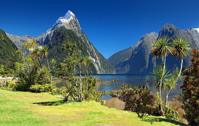
- fjords : Fiordland has numerous fjords with access to the Tasman Sea or the southern Pacific Ocean. Unlike in Norway, where the deep valleys created by glacial movements towards the sea all bear the name Fjord in their name, the fjords of New Zealand were mostly sound, but sometimes also called channel, arm, reach, inlet or passage.New Zealand’s most famous fjord by far is Milford Sound, which attracts many tourists every year and is accessible via the 120 km New Zealand State Highway 94 and the 53.5 km Milford Track. The Doubtful Sound and the Dusky Sound also have a certain degree of popularity and are popular with tourists. But the fourteen other sounds are less well known in the rules and can, if at all, be approached and visited under restrictions only from the sea side.Milford Sound, the most visited in Fiordland, is the only one accessible by road.
Twelve fjords, some stretching more than 40 km inland, and two coves leading to three more fjords, extend along the coast from Milford Sound in the north to Preservation Inlet in the south. In general, the fjords widen from north to south as the mountains decrease in altitude.
,Milford sound , Sutherland Sound , Bligh sound , George sound , Caswell sound , Charles sound , Nancy sound , Thompson Sound , Doubtful Sound , Dagg Sound , Breaksea Sound , Dusky sound , Chalky Inlet , Preservation Inlet. - Milford Sound. The road to Milford Sound is one of the most beautiful mountain roads in the world. Visitors should plan plenty of time for the almost 120 km (at least 3-4 hours), as most of them stand quite unprepared in front of the magnificent natural scenery. Many smaller walks lead to vantage points and photography .
- Marine Protected Areas : Fiordland has a total of ten marine protected areas with a total area of 10,298 hectares. Two of them were expelled in 1993. The others followed in 2005. In all fjords, even where no protected areas have been designated, restrictions apply to fishing and boating. The boat owners are obliged to keep their underwater vessel clean, do not discharge any wastewater into the waters of the fjords and must observe restrictions on anchoring. For anglers there are restrictions on the size and quantity of individual fish species that may be fished. The same applies to all lobster species that live in the fjords.
- Fiordland National Park : The Fiordland National Park is today largely identical to the Fiordland region. On February 23, 1904 expelled with about 1 million hectares as a National Reserve (National Reserve), the area was awarded in 1952 the status of a national park. In the following years, other areas, such as the Hollyford Valley, the Waitutu Forest and Solander Iceland have been assigned to the National Park, so that the park today covers about 1.26 million hectares.
- The small town of Te Anau is located directly on the lake of the same name, about halfway between Queenstown and Milford Sound. Although the city, apart from hiking trails poor in tourist attractions, but with its numerous shops, banks, restaurants and accommodation offers an ideal base for exploring the region.
Activities : sightseeing / photo opportunities / trekking / Scuba diving experience / Native birdlife / Te Anau Glowworm Caves / Fishing / Overnight cruise / Kayaking / Helijet / Fiordland Jet Boat and Bike Combo Tours
Go next : Milford Sound / Te Anau is a small town on the shore of Lake Te Anau, in the Southland region of the South Island of New Zealand. It is the gateway to Fiordland and Fiordland National Park.