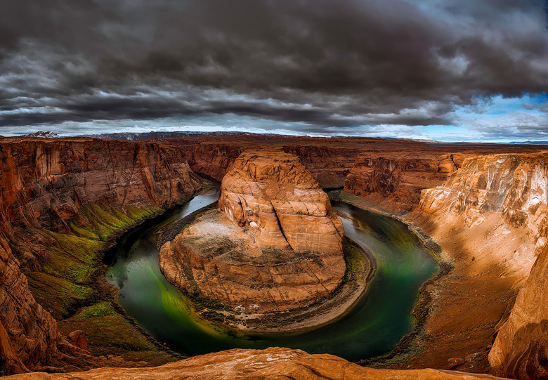
Horseshoe Bend is a horseshoe-shaped incised meander of the Colorado River located near the town of Page, Arizona, in the United States.
Horseshoe Bend is located 5 miles (8.0 km) downstream from the Glen Canyon Dam and Lake Powell within Glen Canyon National Recreation Area, about 4 miles (6.4 km) southwest of Page. It is accessible via hiking a 1.5-mile (2.4 km) round trip from U.S. Route 89, but an access road also reaches the geological structure, as it is part of a state park.
Horseshoe Bend can be viewed from the steep cliff above. The overlook is 4,200 feet (1,300 m) above sea level, and the Colorado River is at 3,200 feet (980 m) above sea level, making it a 1,000-foot (300 m) drop. The rock walls of Horseshoe Bend contain hematite, platinum, garnet, and other minerals.
Access : Coordinates: 36.879444, -111.513889 / Horseshoe Bend is just south of Page, Arizona. From the Glen Canyon Dam on US-89 head south for 5.1 miles. You’ll pass along the edge of Page, Arizona. At around 5 miles from the Glen Canyon Dam, you’ll see a sign for Horseshoe Bend Overlook. Turn right into parking area. If coming from the south, take US-89 north to Page, Arizona and before coming into town you’ll see a Horseshoe Bend Overlook sign. Turn left into the parking lot.
Go next : Lees Ferry / Grand Canyon / Glen Canyon / Zion National Park / Monument Valley / Antelope Canyon