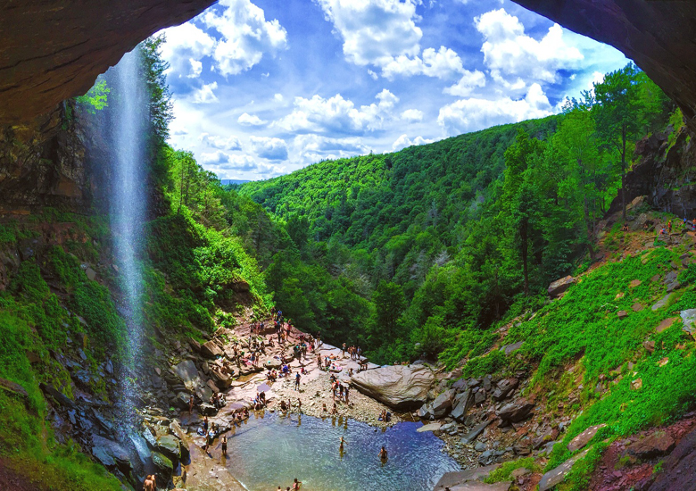
Kaaterskill Falls is a two-stage waterfall on Spruce Creek in the eastern Catskill Mountains of New York, between the hamlets of Haines Falls and Palenville in Greene County. The two cascades total 260 feet (79 m) in height, making Kaaterskill Falls one of the highest waterfalls in New York, and one of the Eastern United States‘ tallest waterfalls.
The waterfalls are one of America’s oldest tourist attractions, being depicted or described by many books, essays, poems and paintings of the early 19th century. Long before Alexis de Tocqueville’s famous essay on America, Kaaterskill Falls was lauded as a place where a traveler could see a wilder image, a sort of primeval Eden. Beginning with Thomas Cole’s first visit during 1825, they became a subject for painters of the Hudson River School, setting the wilderness ideal for American landscape painting. The Falls also inspired “Catterskill Falls”, a poem by William Cullen Bryant.
Access : The sign on Route 23A that guides people to a hiking trail to Kaaterskill Falls.
While the falls are on public land, they can only be reached via the Kaaterskill Falls Trail, a state-maintained yellow-blazed path running 0.4 mile (650 m) uphill from New York State Route 23A, the only road through the clove. This has presented two safety problems. First, the trail itself climbs rather steeply from the road, along the sometimes steep and rocky slopes alongside the creek. Challenging enough for experienced hikers, as the most-hiked trail in the Catskill Park it is used much by casual visitors who may be ill-prepared for the terrain between the road and the falls. The frequent traffic has compounded the trail’s problems.
Second, the trail is served by two parking lots along 23A, both of which require a walk of at least 0.2 mile (400 m) to reach the trailhead at Bastion Falls, just above 23A at a bend in the road. Due to both the rugged surrounding terrain and the limitations placed on Forest Preserve land by the state constitution, New York’s Department of Transportation (DOT) has been unable to expand the narrow shoulder on either side of the road, requiring that visitors walk very close to high-speed traffic, including trucks, some of which are in the middle of descending a pronounced grade. The risk of serious accidents is great. Both DOT and DEC have indicated a willingness to develop a solution that will accommodate their concerns, however this has not happened as of 2006. Some hikers try to avoid this by parking near the Laurel House site or at North-South Lake and following the closed route of the former Escarpment Trail; this is equally risky as it is very near the edge of the falls
Directions: The Kaaterskill Falls hiking trail is accessed via I-87 Exit 21. Located on Rt. 23A west of Palenville, you will find the trailhead about three miles west of the village. From a small parking area on the south side of Route 23A, the moderate, 1.4 miles round-trip trek winds up a well-traveled path offering views of nearby Bastian Falls.Coordinates: 42.193234, -74.063044