The Picos de Europa are a mountain range located along the northern coast of Spain, between the autonomous communities of Asturias, Cantabria and Castile and Leon, and forming part of the Cantabrian Mountains, although they are often considered as a separate entity, due to their formation most recent.
The name Picos de Europa is due to the fact that these are the first European mountains visible for ships arriving from America. This limestone formation extends through Asturias, Cantabria and Castile and Leon, standing out for its altitudes, in many cases above 2500 meters, near the Cantabrian Sea, since at its northernmost point only 15 kilometers from the coast. Geographically, the Picos de Europa are in the line of the Cantabrian Mountain Range and are, however, considered as an independent unit of the Cantabrian Mountains, as their formation appears to be more recent.
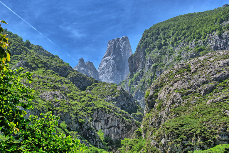
The Peaks of Europe are divided into three great massifs: the Western or Cornion, the Central or Urrieles, and the Eastern or Andara. The main summits are : Torre de Cerredo 2,648 m ,
Pena Vieja 2,615 m , Naranjo de Bulnes 2,519 m , Gorges dug by torrents with fishy waters circumscribe this block of primitive limestones and cut it, cutting it into three massifs, Occidental -or Cornion, Central or Los Urrieles and Oriental – or Andara. Impressive parades coexist with the high peaks jagged by erosion and snow-capped which constitute a magnificent backdrop.
The Cerredo Tower, or Torrecerredo, with its 2,648 m, is the highest peak of the peaks of Europe.The southern slope, with a softened profile, opens onto less steep but more severe landscapes.
Its main rivers are : the Rio Stamp, which waters Cangas de Onis,the Cares,the Rio Deva.The majority of the rivers running through the peaks of Europe are in very narrow gorges.
caving : In the limestone mountains of Picos de Europa are about 300 caves, which have been increasingly studied scientifically in recent years. The largest caves are La Oliseda 806 m , La Horcadina 803 m , Los Mandriles 200 m and El Sumidero 170 m . In 2002 and 2003 two more caves were discovered, the “Sima de la Cornisa” at 803 m and the “Torca Magali” at 400 m. The speleologists have since discovered that the origin of the cave “Torca Magali” under the cave “Sima de la Cornisa” begins, so that together form a depth of 1507 m. The composite of the two caves is one of the second longest cave in Spain. The entrance to the cave is only 2 km from the mountain station of the cable car.
Access : Coordinates: 43.2, -4.8 / By train : From Madrid, Asturias can be reached by train in four and a half hours / By car :
Asturias is connected to the Spanish motorway network. There are direct connections towards Leon – Madrid (AP66 / A6) and Santander / Bilbao (A8). One must make sure that many routes of the A8 in the direction of Galicia are still under construction
By bus : The company ALSA offers numerous destinations both within Spain and abroad.
Highlights :
- Parque nacional de los Picos d’Europa – National Park of the Picos d’Europa : Since 1995, most of the region constitutes the Picos de Europa National Park, which extends into the Autonomous Communities of Cantabria, Asturias and Castile and Leon the Asturian side was the first national park in Spain.
- Ruta de Cares – Cares Trail : The Cares Trail runs along the Cares in a narrow gorge called the divine gorge. First built as a canal maintenance road, it has become one of the most famous and spectacular hiking trails in northern Spain.
- Karst Museum In Santiyan : this facility focuses on the cave systems in the area.The interpretation center is located in Santillan, a small town in the council of Amieva, and it recreates the rock habitat of Picos de Europa, thanks to the study conducted in the cave of Collubil and the karts, and the different materials and documents originals that have been found, such as flint axes and other archaeological remains.
- Covadonga : To the southeast of Cangas de Onis at 12km, Covadonga is the historical site of the battle that marked the destiny of Spain.In this parish is the Santurio del Real Sitio de Covadonga, with the Holy Cave and the Basilica of Covadonga, forming part of the Picos de Europa National Park. Nearby, already outside the parish, are also known as Lagos de Covadonga.
- Cangas de Onis : This city is located northwest of the Picos de Europa.Cangas de Onis is a place in the east of the Spanish province of Asturias. It is the capital of the municipality of the same name and lies in the valley of the rivers Sella and Guena.More than 2000 hectares of the council are part of the Picos de Europa National Park. Inside the park is the monumental complex of Covadonga, where the Reconquista began in 722. 12 kilometers from Covadonga, are the so-called Covadonga lakes (there are three: the Enol, the Ercina and the Bricial, although this alone it has water during the thaw), of great relevance in the cycling field. In the capital of Cangas de Onis, is known as “Puente Romano”, although its construction actually dates from the Middle Ages.
- Arenas de Cabrales : Las Arenas is a village and a parish of the Asturian council of Cabrales, in Spain. Sands of Cabrales. Another gateway to the national park, just north of the mountains, this town has shops, bars, restaurants, hotels and hiking trails. On the outskirts of the town, towards the national park, there is a cheese museum inside a cave. Also very interesting is the “cheese and cider route” in the town of Asiegu.The Cabrales area is famous for its strong blue cheese.
- Bulnes : Bulnes is a small village of the municipality of Cabrales in Asturias in Spain. It is a very isolated traditional village in the heart of the Picos de Europa, which has become a tourist starting point for hiking trails in the mountains and mountaineering.
- Cain : Cain de Valdeon, commonly known as Cain, is a village belonging to the municipality of Posada de Valdeon, province of Leon, Community of Castilla y Leon, Spain. It is located in the Valdeon Valley, 460 meters high, in the Picos de Europa, constituting the starting point of many hiking trails, the most famous of which is the one that crosses the throat of Cares.The great limestone heights that surround the town, among them the Robliza peak that reaches 2,245 meters high and the Jultayu peak with 1,940 meters.
- Santa Maria de Lebena Iglesia – Santa Maria de Lebena Church : The church of Santa Maria is located in the town of Lebena, municipality of Cillorigo de Liebana, (Cantabria). It is one of the best testimonies of pre-Romanesque art in Spain, framed within the so-called «repopulation art» or Mozarabic. It was declared a National Monument on March 27, 1893.
- Potes : The main city on the eastern side of the Picos de Europa.The town is the main town of the Comarca Liebana and recognized as a cultural asset (Bien de Interes Cultural) in the category Conjunto historico-artistico.The town is located at the meeting point of four valleys, at the confluence of the Rio Quiviesa and Rio Deva, born in the Picos de Europa. Potes enjoys a Mediterranean microclimate that allows the cultivation of vines. The proximity of the Picos de Europa and the coastline, the historical richness and the Santo Toribio de Liebana Monastery make it a summer and winter tourist center.
- Sotres : Sotres is a village in the Asturian municipality of Cabrales, Spain. It is 19 km from Carrena.It is the highest village of the Picos de Europa, with 1050 meters above sea level, and belongs to the municipality of Cabrales. Due to its location, it can only be accessed by road. It is one of the best places in Asturias to live a totally alpine experience, with green hiking areas, natural pits and stone architecture typical of a mountain town.
- Lagos Enol y Ercina – Enol and Ercina lakes : Lake Ercina is a small mountain lake in northern Spain, located in the Picos de Europa, in the Cantabrian Mountains. It is close to Lake Enol and together they form the complex known as Lagos de Covadonga, in the Principality of Asturias, within the Picos de Europa National Park.
- Fuente De : Fuente De is a district of the Spanish community Camaleno in the autonomous community of Cantabria. The town is part of the National Park Picos de Europa, it is located at about 1100 m altitude in a south-open basin, the semi-circular is surrounded by up to 300 m high rock walls. The special location makes it interesting for tourists as well as for geomorphologists. The Spanish word “Fuente” means “source”, in Fuente De the river Rio Deva springs.
- The medieval bridge of La Jaya, over the Cares River, Located within the Picos de Europa mountain range, the province and autonomous community of Asturias, in northern Spain.
Go next : In the West: Luarca, Cudillero, Tapia de casariego, Somiedo, Teverga, Los Oscos.
/ In the Center: Luanco and Candas, Central Mountain and Mining Valleys. / In the East: Llanes, Cangas de Onis (Covadonga) and the Picos de Europa, Ribadesella, Villaviciosa or Lastres (Current San Martin del Sella in the “Doctor Mateo” Series