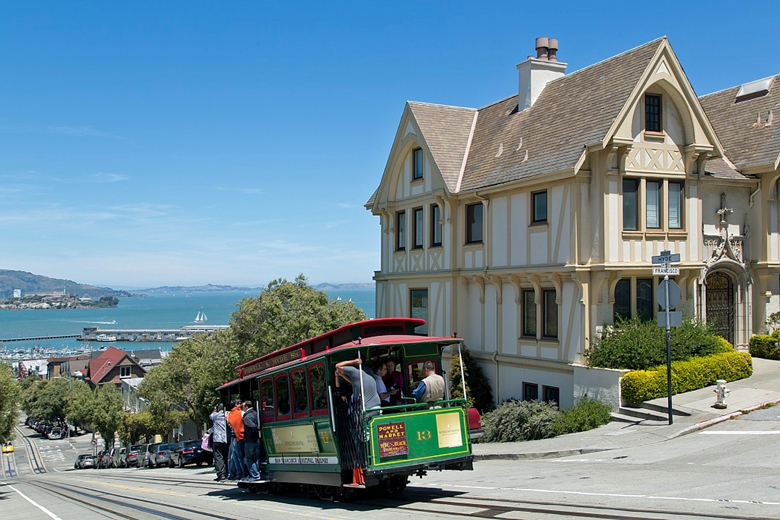
The San Francisco Cable Cars began operations in 1873 and since then they have been an essential element of the city.
The first successfully operating cable street railway was opened in San Francisco in 1873, it was called Clay Street Hill Railroad. The founder of this road was Andrew Smith Hallidie, and the chief engineer was William Eppelsheimer. The patent for this design belonged to Ebner Doubleday. On the line, cars were used that clung to the cable using a special mechanism.
At the end of the 19th century, cable car lines were built and operated by numerous private operators.
At the end of the 19th century, cable car lines were built and operated by numerous private operators.
A characteristic feature of the cable tram is the presence of wide side steps and handrails on the cars. Passengers are allowed to travel outside the wagons, which is why this method of travel is very popular among passengers.
Popular with tourists, While trams are used to some extent by passengers, the vast majority of its 7 million annual users are tourists. They are among the most important tourist attractions in the city, along with Alcatraz Island, the Golden Gate Bridge and Fisherman’s Wharf. The system is listed on the National Register of Historic Places.
Popular with tourists, While trams are used to some extent by passengers, the vast majority of its 7 million annual users are tourists. They are among the most important tourist attractions in the city, along with Alcatraz Island, the Golden Gate Bridge and Fisherman’s Wharf. The system is listed on the National Register of Historic Places.
Access : Coordinates:37.795556, -122.4075 / Area served : Chinatown, Financial District, Fisherman’s Wharf, Nob Hill, Russian Hill, Union Square
Route network : The system general starts operating at 5:32am each day and shuts down at 1:30am.
- California St. line: 1.4 mi (2.3 km) Line 61: extends west from the terminus at the corner of California & Market, close to the intersection of Market Street and Embaracadero. The line runs all the way along California Street, first abruptly rising to Nob Hill, and then smoothly descending to the final Van Ness Avenue.
- Powell-Mason line: 1.6 mi (2.6 km) Line 59 : follows a common path with the Powell-Hyde line to Mason Street, where it intersects with Washington, Jackson Streets. There, she turns right and drives down Mason Street downhill, just outside Columbus Avenue, turning left at a 45-degree angle on Taylor Street to the final Taylor and Bay. This terminal is located near the embankment and the Fisherman’s Wharf.
- Powell-Hyde line: 2.1 mi (3.4 km) Line 60 : This line runs north, with a large slope uphill along Powell Street from the final Powell and Market Streets, to the intersection with California Street. The Powell-Hyde line runs along the top of the hill. Having descended from the hill, this line turns left to Jackson Street, where it rises again (Dexon Street is one-way, wagons go down Washington Street), to a high point on Hyde Street. There she turns right, where she goes abruptly downhill along Hyde Street. To the end at Girardelli Square, where it unfolds in a public garden not far from a miniature beach. There is also a museum of the navy.
Note : The current cable car fare is $7.00 and all fares are one way / Buy a Visitor Passport in case you are going to be in the city for a while. Through this passport, you can get on the funiculars unlimited, as well as trams, municipal buses and the municipal subway.It is also possible to buy a CityPASS at any of its associated attractions.
Activities : sightseeing / photo opportunities / Sit on the side that faces the bay to get the best views
Go next : 49-Mile Scenic Drive , The 49-Mile Scenic Drive is a designated scenic road tour highlighting much of San Francisco, California./ Fisherman’s Wharf / Alcatraz Island