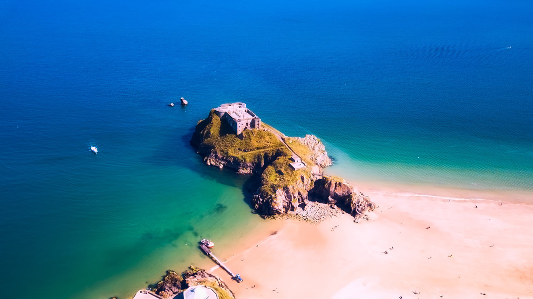
St Catherine’s Fort is a 19th century fortress, a Fort Palmerston, located on a small Tidal island in Pembrokeshire, Wales,United Kingdom.
The fort was recommended by the Royal Commission on the Defense of the United Kingdom which had been established in 1859 by Lord Palmerston in response to a threat of invasion by Emperor Napoleon III of France. Considering the defense of the Royal Dockyard at Pembroke Dock and the anchorage of Milford Haven, the commissioners felt that an enemy force risked launching a landing on a beach on the south coast of Pembrokeshire and attacking naval installations by land. The Commissioners envisioned a chain of coastal artillery forts stretching along the coast from Tenby to Freshwater West covering all potential landing sites. In fact, only Tenby Fort was built.
St Catherine’s Fort was designed by Colonel William Jarvoy. The fortress was a simple rectangle with three protective turrets- batteries mounted on two opposite sides to protect the RML 7-inch gun with an iron shield. The other three turrets were equipped with RML 9-inch 12-ton cannons on the roof. The north-facing cannon was intended to defend the beach overlooking Tenby Harbor and Saundersfoot, and the south-facing cannon was intended to defend the beach overlooking the Penally.
The fortress is currently open it to the public – Exterior only .The fort currently organizes tours in which visitors can explore.
Access : Coordinates: 51.6706, -4.6919 / Address:St Catherine’s Island, Tenby SA70 7BP / The island can be reached on foot via the beach at low tide. / Tenby is approximately 12 miles (19 km) south of European Route 30, which connects London to the Fishguard Ferry Terminal, which has a ferry service to Rosslare in Ireland. The M4 motorway coming from Londun leads via Bristol to Pont Abraham northwest of Swansea, further on the four-lane A48 and A40 to St Clears, then onto the A477 and turn off in Kilgetty to Tenby.
Highlights :
- The entrance on the west side (land side) of the fortress is connected to a lifting bridge that crosses the moated settlement, and there are two caponier also called “flanking galleries”. It was protected. Each caponier had three floors and had several crenellated firearms. The basement on the east side was used as an ammunition artillery storage. The fortress also had a capacity of 150 people.
- In 1895, control of the fortress was delegated to the Royal Naval Reserve, who installed a BLC 5-inch gun for training on the “Youngman’s compression platform.”
- The island Formed from a limestone outcrop, with an average height of 25 m, the island is riddled with tidal caves. The island is about 200 m long and 60 m wide.The island gets its name from an old chapel -disappeared long ago- dedicated to Santa Caterina.
- In 2016, “The Last Problem,” the third and final episode of the fourth series of the BBC television series “Sherlock” was filmed on the island.
- The island is known informally as St. Catharine’s Rock and the immediate area in front of it is also known as “The Catterns”..The area below the water level at high tide is designated as a special science area of interest.
Opening Hours: Exterior Open daily. – Interior : currently closed – Free entry.
Activities : sightseeing / photo opportunities / Boat trips / Walk the Pembrokeshire Coast Path.
Go next : Castle Beach / Town of Tenby , a picturesque city in South Wales. / Pembroke , the traditional county town of Pembrokeshire in south-west Wales / St Davids is Britain’s smallest city and home to Wales’ most important cathedral. / Caldey Island. A Cistercian Monastery located on an island just off Tenby’s coast.