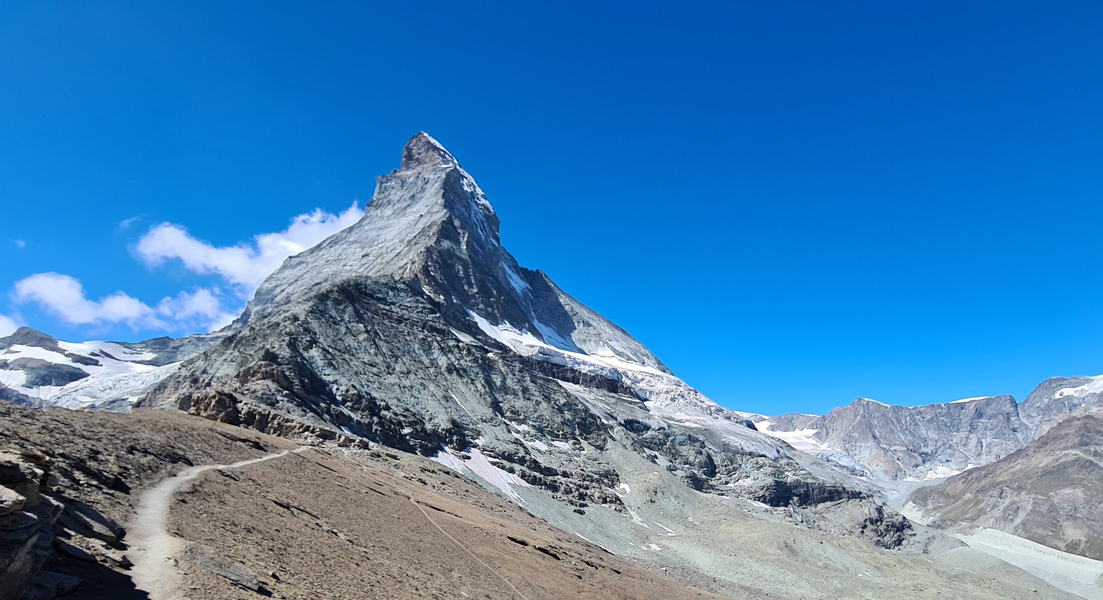
The Matterhorn is a mountain in the Western Alps (Pennine Alps – Weisshorn and Matterhorn Alps – Bouquetins-Cervino chain), along the border between Italy and Switzerland ,west of the Monte Rosa massif, east of the Grand Combin and south-west of the Mischabel massif.
The Matterhorn, with a height of as much as 4478 meters, is the highest peak in Europe.
The path to this mountain is considered very dangerous due to steep ledges, cliffs, frequently changing climatic conditions, rock falls and avalanches. Therefore, most tourists prefer to simply admire the Matterhorn and take pictures.
The path to this mountain is considered very dangerous due to steep ledges, cliffs, frequently changing climatic conditions, rock falls and avalanches. Therefore, most tourists prefer to simply admire the Matterhorn and take pictures.
The first successful ascent of the Matterhorn was made by the British in 1865, that is, almost 150 years ago. It ended in tragedy – four out of seven participants died due to a broken rope. Nevertheless, the number of tourists coming to the Matterhorn region has steadily increased since the middle of the 19th century, especially after a railway station opened here in 1933, connecting the Matterhorn region with the main Swiss cities.
Climbing the Matterhorn still exerts great fascination today, but is reserved only for experienced mountaineers. The two normal routes, even if facilitated by the laying of various fixed ropes, follow those of the first ascents; the one that starts from Zermatt runs along the north-east ridge “dell’Hörnli”; the one that starts from Cervinia develops along the south-west ridge “del Leone” (Arête du lion). Another fairly popular but more demanding route is the one along the “Zmutt” ridge.
Access : Coordinates: 45.976389, 7.658611 / The nearest international airports from Zermatt are located in Geneva and Zurich at a distance of 230-250 kilometers. You can buy a train ticket or rent a car for the trip.
/ The Matterhorn is accessible either by the Valtournenche, in Italy, or by the valley of Zermatt, in Switzerland.
/The usual pattern of ascent is to take the Schwarzsee cable car up from Zermatt, hike up to the Hörnli Hut elev. 3,260 m (10,700 ft). / By the The Glacier Express : The “express” train connecting railway stations of the two major mountain resorts of Zermatt and St. Moritz via Andermatt in the central Swiss Alps.
Highlights :
- Climbing the Matterhorn : The nearest settlements from the Matterhorn mountain are Zermatt (Switzerland) and Breuil-Cervinia (Italy) Climbing one of the most beautiful and, perhaps, the most famous peaks in Europe along the classic path from Switzerland. A steep and long rocky ridge, snow and ice-covered rocks require maximum concentration and good preparation from climbers. Therefore, recommend this ascent only to experienced climbers who have at least been to peaks higher than 4000 meters and already have experience in rock climbing.
- Swiss normal route : The normal route starts from the Hörnli hut, located at 3,260 meters. It can be reached from Zermatt by the Schwarzsee cable car, There is a 700-meter drop to the hut then a 1,200-meter drop to the top. Difficulty (Hörnli ridge) 20: AD (quite difficult), passage of 3 in climbing, fixed ropes were installed near the summit to facilitate its ascent.
- Italian normal route : The normal Italian route, starting at Breuil, almost entirely follows the southwest ridge, called the Lion ridge. It was inaugurated by the Valtournain guide Jean-Antoine Carrel on July 17, 1865. The ascent of the Italian side involves three stages:from Breuil (2,012 meters) to the Duc des Abruzzes refuge in Oriondé (2,802 meters), from the Duc des Abruzzes refuge to the Jean-Antoine Carrel refuge (3,830 meters),from the Jean-Antoine Carrel refuge to the summit (4,478 meters).At Breuil we take path no 13 (along a dirt road) to reach the Duc des Abruzzes refuge in Oriondé in two hours.
You can also reach the refuge by first joining Plan Maison (2,561 meters) by the ski lifts and continuing on foot for about an hour and a half. - Due to its pyramidal shape, the Matterhorn has four main ridges, through which most of the ascent routes pass. The easiest ridge, the one taken by the normal route, is the Hörnli ridge : it is located between the east and north faces, facing the Zermatt valley. Further west is the Zmutt ridge (Zmuttgrat) 22, between the north and west faces. Between the west and south faces is the Lion ridge (Liongrat) 23, also known as the Italian ridge, which passes through Tyndall peak, the summit of the southern part of the west face, where the upper part of the face begins. Finally, the south face is separated from the east face by the Furggen ridge (Furggengrat).
- Its north face is one of the three great north faces of the Alps with those of the Eiger and the Grandes Jorasses./ Waterfall along the path to the Duc des Abruzzo refuge. / The Lion Pass between the Lion’s Head and the Matterhorn.
- The Carrel cross, located at the place where Jean-Antoine Carrel disappeared in 1890 while returning from an ascent after having saved his clients / The lion’s ridge you can see the Carrel refuge, the Grande Tour and the Rooster ridge.
- The Matterhorn is the logo of the Toblerone chocolate brand from 1970 to 1987. / The Matterhorn is on the box of Alpen muesli (Weetabix)./ The Matterhorn is also the logo of the Swiss winter sports resort of Zermatt./ The Matterhorn is the logo of the Swiss watch brand Matterhorn-1865.Walt Disney was inspired by this mountain, reduced to the 100th, to host the Matterhorn Bobsleds attraction located in Fantasyland at Disneyland. / The Europa-Park amusement park, located in Germany, was also inspired by this mountain to name a roller coaster course, the Matterhorn-Blitz.
- Alpine refuges: Schönbielhütte (2694 m) – near the Zmutt Glacier, used for ascents along the Zmutt ridge and the west face / Bivouac Oreste Bossi (3345 m) – upstream of Colle del Breuil, at the foot of the Furggen ridge In the past there was also the Lonza Bivouac (Lonza-Biwak), located at 2970 m on the Zmutt ridge. Owned by the Zermatt Alpine Guide Club, the bivouac was destroyed by an avalanche in 2001 and has never been rebuilt. / Duca degli Abruzzi refuge at Oriondé (2802 m) – along the Italian normal route / Jean-Antoine Carrel Refuge (3830 m) – along the normal Italian route, usually preferred to the Oriondé Refuge for overnight stay / Hörnlihütte (3260 m) – main refuge along the Swiss normal route (Hörnli ridge) / Solvayhütte (4003 m) – emergency bivouac along the Swiss normal route.
- cable car : Schwarzsee – cable car station at 2,583 m. is the starting point for ascents of the Matterhorn – and for the Matterhorn glacier Trail. In winter, Schwarzsee offers direct access to the ski pistes.
Activities : Mountaineering : Climb the Matterhorn – one of the most prestigious peaks in the world / Skiing : Breuil-Cervinia Valtournenche Zermatt ski area- Klein Matterhorn area – Gornergrat area – Sunnega-Rothorn area.
Go next : Zermatt is one of the most famous mountain resorts in Switzerland. / Saas-Fee is the biggest town in the Saas valley in the Swiss canton of Valais. / Swiss Alps Jungfrau-Aletsch is a protected area and a UNESCO World Heritage Site / The Italian town of Breuil-Cervinia in the Aosta Valley / Courmayeur is a skiing and mountaineering resort at the head of Valle d’Aosta.