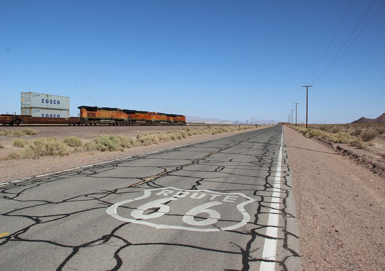
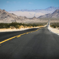
Route 66 (aka US 66) was a historic highway in the United States extending from Chicago to Los Angeles. It crossed much of the American Midwest, Great Plains, and Southwest. Although Highway 66 is no longer commissioned as a US Highway, you can still “get your kicks” on the path it took through the United States as more than four-fifths of it still remains drivable (though not always well-marked) as a collection of state highways and local roads.
Understand : Route 66 is one of the essential icons of America, both for Americans and for people abroad. It represents a multitude of ideas: freedom, migration West, and the loneliness of the American heartland. The highway marked the final taming of the Wild West as it opened in 1926; the last section of the route was paved in 1938. Until the Interstates were built in the post-war years, Route 66 was, together with the Lincoln Highway, among the few reliable roads across the Rocky Mountains.
It soon captured America’s imagination. John Steinbeck, in his 1940 novel Grapes of Wrath, chronicled the migration along Route 66 of thousands of farmers leaving the Dust Bowl of Kansas and Oklahoma during the Great Depression, trying to reach a better land in California. Steinbeck posited the road as an almost hostile force, draining money, energy, and enthusiasm from the optimistic Okies.
Later representations of the road were a little more upbeat. Probably most famous is musician Bobby Troup’s eponymous tribute song, which enjoined listeners to “get their kicks on Route 66”. A TV show in the 1960s, also called “Route 66”, featured two young men exploring America’s highways. Although Jack Kerouac only mentions 66 briefly in his book On the Road, it acquired something of the aura of Beatnik cross-country driving.
In 1985 the aging highway was decommissioned, less than a year after the last stretch had been overlaid or routed around by broader, newer interstate highways. Though air travel has made long road trips less necessary, the embedded idea of Route 66 and the associated nostalgia refuse to die – as demonstrated by the 2006 Disney/Pixar movie Cars – and thousands of kicks-seekers continue to follow the remnants of the road from Chicago to Los Angeles to this day.
Many towns, such as Strafford have festivals (Route 66 Days) and Motor Cruises (Route 66 Cruise) each year which keep the history alive, along with providing excellent opportunities for enthusiasts to drive the existing road.
Prepare : n The Grapes of Wrath, to prepare for their trip to California, the Joad family packs everything on their farm into a $50 jalopy, and kills their two remaining pigs to make a barrel of salt pork to feed the 14 people on board. This is probably overkill for travellers in the 21st century. However, you should realize that some parts of the trip are in remote areas; make sure that you have extra food and water, just in case. Food for your car is as important as food for yourself. In the western half of the route, gas stations (at least open ones) may be up to 100 mi (160 km) apart, so know your vehicle’s range and fill up accordingly. Repair services are equally sparse; make sure your car is in good repair before setting out, and have a spare tire.
The desert parts of this route get really hot and lonely. If you’re driving, carry a big cooler, not one of those styrofoam jobs, and fill it with ice every day. Soak a hand towel in the icy water and wear it around your neck. No, not really, but this is a good trip on which to drive a car that has air conditioning. (The moist-towel routine really does help if you’re on a motorcycle, though.)
Lodging along this route is generally not too hard to find, and in most areas you’ll probably be able to find something basically satisfactory on the spur of the moment. However, it never hurts to make reservations, and at Flagstaff and (if you take the recommended alternate route through New Mexico) Santa Fe, reservations border on mandatory. Additionally, some other waypoints get full at certain times of the year, for example Albuquerque during the first or second weeks in October when the International Balloon Fiesta is in full swing. Plan and reserve accordingly.
Get a good turn-by-turn description of the old Road. Signs for it are sparse, and in dense traffic easily missed or worse, they have been stolen by souvenir hunters. A turn-by-turn description can be found at the historic66.com website. The eight-state “Here it is!” paper map set is also a good, established reference. Entire printed books have been devoted to listing individual landmarks along the route.
Over time Route 66 got realigned a few times, you will need to make choices as to which alignment you will follow. A first example of such a major choice are the Santa Fe and Los Lunas loops that was cut-off by a more direct east-west route in 1937. Similarly, the alignment south of Springfield, Illinois, changed significantly.
For a background experience of American industrial history until World War II, follow the American Industry Tour from Boston to Chicago, which connects naturally to Route 66 in space and time. The Motorcities Tour showcases the automotive industries around Detroit, with an opportunity to see many classic cars from the Golden Age.
Route : Note: State highways are referenced by their postal abbreviations, e.g., MO 66 means Missouri State Highway 66, IL 4 means Illinois State Highway 4, etc. Attractions listed in bold are discussed toward the end of the article under the Attractions section.
- Day 1: Chicago to Springfield, Illinois : ( Chicago > Cicero > Joliet > Gardner > Dwight > Pontiac > Chenoa > Bloomington-Normal > McLean > Atlanta > Lincoln > Williamsville > Sherman > Springfield )
- Day 2 : Springfield to St. Louis : ( Springfield > Litchfield > Mount Olive > Staunton > Hamel > Edwardsville > Mitchell > Missouri border > St. Louis )
- Day 3 : St. Louis to Springfield, Missouri : ( St. Louis > Eureka > Pacific > Gray Summit > St. Clair > Sullivan > Bourbon > Cuba > Rosati > Rolla > Doolittle > Jerome > St. Robert > Buckhorn > Sleeper > Lebanon > Phillipsburg > Conway > Vance > Marshfield > Strafford > Springfield )
- Day 4 : Springfield, Missouri to Oklahoma City : ( Springfield > Halltown > Paris Springs Junction > Spencer > Phelps > Rescue > Plew > Avilla > Carthage > Carterville > Webb City > Joplin > Kansas border > Galena > Riverton > Baxter Springs > Oklahoma border > Commerce > Miami > Afton > Vinita > White Oak > Chelsea > Foyil > Claremore > Catoosa > Tulsa > Oakhurst > Sapulpa > Kellyville > Bristow > Depew > Stroud > Davenport > Chandler > Warwick > Wellston > Luther > Arcadia > Edmond > Oklahoma City )
- Day 5 : Oklahoma City to Amarillo : ( Oklahoma City > Bethany > Yukon > El Reno > Hydro > Weatherford > Clinton > Foss > Canute > Elk City > Sayre > Erick > Texola > Texas border > Shamrock > McLean > Jericho > Groom > Alanreed > Conway > Amarillo )
- Day 6 : Amarillo to Albuquerque : ( Amarillo > Bushland > Wildorado > Vega > Adrian > Gruhlkey > Glenrio > New Mexico border > San Jon > Tucumcari > Santa Rosa > Moriarty > Edgewood > Albuquerque )
- Day 7 : Albuquerque to Flagstaff : ( Albuquerque > Grants > Gallup > Arizona border > Petrified Forest National Park > Holbrook > Joseph City > Winslow > Flagstaff )
- Day 8: Flagstaff to Barstow : ( Flagstaff > Williams > Ash Fork > Seligman > Peach Springs > Kingman > Oatman > Topock > California border > Needles > Chambless > Amboy > Bagdad > Siberia > Klondike > Ludlow > Newberry Springs >Daggett > Barstow )
- Day 9 : Barstow to Santa Monica : ( Barstow > Lenwood > Helendale > Oro Grande > Victorville > San Bernardino > Rialto > Fontana > Rancho Cucamonga > Upland > Claremont > Pomona > La Verne > San Dimas > Glendora > Azusa > Monrovia > East Pasadena > Pasadena > Los Angeles > Hollywood > Beverly Hills > Century City > Santa Monica )
Six alternate alignments
Original alignment through Southern Illinois
Much of the original alignment is now Illinois State Highway 4.
From Peoria Road, turn west on Taintor Road, which will curve around and become Fifth Street. At NORTH Grand Avenue, turn west, then south on Second St. At SOUTH Grand Avenue, continue to MacArthur Boulevard, which will eventually become Wabash Avenue. Turn south on Chatham Road until it reaches Interstate 72 (no access), head west on the frontage road to IL 4. Head south on IL 4 (For a side trip, head east on Ostermeir Road to Covered Bridge Road and continue east to a covered bridge over Sugar Creek). At Snell Road, leave IL 4 and go west (this section of road is brick and has been placed on the National Register of Historic Places). The road will curve around and become Curran Road. It will rejoin IL 4. Head south on IL 4. Past Auburn, go south on Planter Road to Ackerman Road. Go west, cross IL 4, and turn back south on Tiller Road. At the junction with IL 4, continue south on IL 4 to Girard. In Girard, turn west on Madison St, then south on Sixth Street. Follow Sixth Street to IL 4, follow IL 4 south and west. At Donaldson Road, turn south and follow until it returns to IL 4. Rejoin IL 4 to Harvest Road, turn south until the road intersects IL 4, then turn south again. In Carlinville, IL 4 turns east onto First South Street (south of the courthouse), follow IL 4 east until IL 4 turns south. Follow IL 4 south all the way to Gillespie. In Gillespie, IL 4 will wind around, stay on IL 4 through town and continue south to Staunton. In Staunton, the “historic alignment” will join Il 4.
Original alignment through St. Louis
From Mitchell, Illinois, head south on IL 203 (Nameoki Road) into Granite City. At Madison Avenue, head southwest (from this point on, the route is marked as “To McKinley Bridge”). This road will eventually become Broadway in Venice. Follow to IL 3 and jog over to the McKinley Bridge.
The McKinley Bridge was owned by the city of Venice, Illinois and operated as a toll bridge. After decades of disrepair due to the lack of toll revenues, the city of Venice closed the McKinley Bridge on October 30, 2001. The state of Illinois attempted to provide money to the city of Venice for repairing the bridge, but was unable to do so because of the outstanding taxes owed by the city. As a result, the city of St. Louis foreclosed on the bridge, delaying reconstruction efforts further. In an agreement reached in June 2003, the states of Illinois and Missouri agreed to take over ownership of the bridge from the city of Venice. Rehabilitation began in 2004 and the original plans for the repairs anticipated a re-opening in late 2005. However, the date was pushed back due to the addition of The Great Rivers Greenway Bikeway tie-in. The Bridge reopened to pedestrians and bicyclists on November 17, 2007 and was fully reopened to traffic on December 17, 2007.
On the Missouri side of the McKinley Bridge, continue west on Salisbury to North Florissant Road. Follow Florissant south as it S-curves into Tucker Boulevard. Turn west onto Market Street. Follow Market Street to Forest Parkway. Follow this to Vandeventer Avenue. At Manchester Road (MO 100), turn west and follow it through the suburbs all the way to Grays Summit to join the historic alignment (from Watson Road). In two places where “Old Manchester Road” branches off MO 100, follow Old Manchester Road.
Historic alignment through St. Louis
The historic alignment is the one marked as “Historic Route 66 in Missouri”. The Manchester Road alignment was intended as a temporary route until Watson Road could be completed. With the MacArthur Bridge closed, it is impossible to drive over the Mississippi River to connect the two routes between East St. Louis, Illinois and St. Louis, Missouri.
From Mitchell, Illinois, go south on IL 203 (Nameoki Road). Follow this to Edwardsville Road where IL 203 continues south towards I-55/I-70. Cross over the interstate into East St. Louis. Turn west on Tenth Street and continue to the MacArthur Bridge.
MacArthur Bridge is closed! MacArthur Bridge brought US 66 to Chotoeau Avenue which had ramps (gone) which connected it to Tucker Boulevard and connected with the historic alignment down Watson Road.
Bypass US 66 around St. Louis
There is really little to recommend this route, however this particular alignment is a long one, therefore it is presented. After crossing the Mississippi River on I-270, exit for Riverview Drive and go north. At the first road on the left (Dunn Road), turn west and follow towards Lewis & Clark Boulevard. Before reaching this road, Dunn Road will curve to become an outer road of the highway. At the first opportunity, head west across the highway, then turn south on the outer road and continue west on Dunn Road as it continues to parallel I-270 all the way into Hazlewood. Dunn Road will eventually curve to the north and form a T-intersection with Taylor Road. Turn west to Lindberg Boulevard (US 67). Head south on Lindbergh Boulevard. (At Manchester Road, the original alignment of Route 66 intersects). Bypass US 66 ends at Watson Road where it rejoins the historic alignment.
Original alignment in Springfield (Missouri)
The original alignment through Springfield, Missouri required a left turn at Missouri Highway 125 just west of Strafford, Missouri. It then turned west on Missouri YY (Division Street) and proceeded past the City Airport and O’Reilly Hospital, turning south at Glenstone Avenue.
A ByPass alignment in later years was constructed West From Kearney and Glenstone avenue, turning South at what is now known as West Bypass Avenue (also US 160), adjoining the original route at the intersection of College and West Bypass.
Original alignment in New Mexico
The original route in New Mexico was quite a bit longer than the current one, and if you use it, you may find it desirable to make some modifications to your waypoints. This is hardly a hardship, as the original route passed right through the heart of marvelous Santa Fe — right through the downtown area, which is so congested that you may be forced to insert an extra night in your trip, not just to see the sights there, but to deal with the traffic! There exists some controversy about the exact route in some places, and some of the very oldest roadway is definitely lost; the route given here is practical, and as close to “authentic” as any.
From the Texas state line, continue west to Santa Rosa following the directions above. West of Santa Rosa, turn north on US 84 (exit 256 on I-40) toward Las Vegas (New Mexico). This is one of the areas where some sources claim that the “original” roadbed is no longer driveable, while others claim that US 84 is authentic along this stretch. You’ll have to stay on the highway, anyway. US 84 does not actually enter Las Vegas itself, but meets I-25 at the tiny town of Romeroville (no services). According to most sources, the current route of US 84, which either follows I-25 or parallels it, is original Route 66 roadbed, switching back and forth across I-25 a few times. At Rowe (near exit 307) the route moves to NM 63 northbound, then to NM 50 eastbound(!) and back to I-25. Interesting digressions through here are to Las Vegas itself (an important point on the Santa Fe Trail with a substantial historic district) and to Pecos National Historical Park on the east side of the Sangre de Cristo Mountains.
The route from here is one of the “controversial” sections: it’s reasonably clear that Route 66 entered Santa Fe via Old Pecos Trail, but less clear how it got there. You’ll be at least “close to” 66 if you leave I-25 at exit 294 and continue west on the Old Las Vegas Highway (NM 300, north frontage road) until it intersects Old Pecos Trail. (To dodge local traffic, stay on I-25 at exit 294 until the Old Pecos Trail exit.) Some sources claim that the route into Santa Fe was on Old Santa Fe Trail, rather than Old Pecos; this road intersects the Old Las Vegas Highway a short distance east of Old Pecos Trail, and the two trails merge just south of downtown. Anyway, the real route-finding fun begins once you’re on Old Santa Fe Trail in the downtown area. Pause here (even if you’re not overnighting in town) and enjoy the scenery, such as St. Francis Cathedral, Palace of the Governors, and so on.
St. Francis Cathedral, at the end of the Santa Fe Trail
You can easily spend several days in Santa Fe sightseeing, but that’s a different article. Once you’re ready to move on, turn left from Old Santa Fe Trail onto Water Street (dodging pedestrians) and then left again onto Galisteo Street which becomes Cerrillos Road, the decidedly un-romantic commercial main drag through Santa Fe. The New Mexico State Capitol Building, also called the Roundhouse for reasons that’ll be obvious when you see it, is nearby. You’ll dodge seemingly perpetual construction on Cerrillos as you head back for I-25, with a number of older motels along the way. The properties north of St. Michael’s are part of Route 66’s history, as they are all located on the historic road and have been around since its heydey. These include the very nice El Rey, the International Hostel, and other properties of varying quality. See the article on where to sleep in Santa Fe for details.
Cerrillos rejoins I-25 at exit 278, but you’ll get off the interstate again at exit 276, where Route 66 followed what is now the south frontage road. The original roadway down La Bajada Hill, a notorious barrier to early Route 66 voyagers, still exists, but is extremely difficult and dangerous to drive and impossible without a high clearance 4×4, so rejoin I-25 at exit 267 and stay on it until exit 248 (Algodones).
If you want to see the top of La Bajada Hill (or drive down it if you’re crazy), on Cerrillos Rd, turn left onto Airport Rd. (NM-284). Straight across onto CR-56 at the intersection with Veterans Memorial Hwy. (NM-599). After 3.3 miles, make a sharp right onto CR-56C. Continue straight as the road becomes a dirt road. Continue for about 6 miles in a more or less straight SW direction (It’s easiest to follow the power line, it ends at one of the two alignments near the top). You will now be at the top of the hill. If you do drive down it, you will end up on Indian Service Route 841.
At Algodones (not much there), turn right (south) onto NM 313 and continue south to Bernalillo. There are more old buildings in this small town, and you might consider a diversion to Coronado State Monument just outside town; hours 8:30am-4:30pm daily (except Tuesdays), $3 admission fee, scenic and archaeological interest. NM 313 continues south to Albuquerque, becoming 4th Street; turn left onto Lomas Boulevard (strong possibility of road construction around here), right onto 3rd Street, on to Central Avenue, and rejoin the route above.


Attractions :
- The Sears Tower in Chicago is a 110-story building (1,450 feet) built in 1974. When built, it became the tallest building in the world, surpassing the World Trade Center Towers in New York City by about 70 feet. It remained the tallest building until the construction of the Petronas Towers in Malaysia in 1998. Its current name is the Willis Tower.
- The Chain of Rocks Bridge was the most famous crossing of Route 66 over the Mississippi River. It was a relatively narrow bridge (reportedly, two semis could not meet on it) and famous for a 22 degree bend about midway over the river. The road is closed to vehicle traffic, but open during daylight hours for pedestrians. From the bridge, the old water intakes for the St. Louis waterworks are visible as is the Gateway Arch. The bend was made to help accommodate navigation on the river.
- The Jefferson National Memorial in St. Louis, Missouri, of which the Gateway Arch is part, was built in 1965 to commemorate westward expansion. The Arch stands 630 feet high and is also 630 feet wide at the base. Underneath it is a free museum about the exploration of the Louisiana Purchase. The other part of the memorial is the old courthouse, where the Dred Scott Decision ruled that a slave did not become a free man because he was taken into a free state.
- Meramec Caverns (fee) is located near Stanton, Missouri. Billed as “The Jesse James Hideout”, a disputed claim, advertisements were painted on barns up and down Route 66, though most are now located in Missouri and Illinois. In the past, before air conditioning, cars could park in the cave entrance while tours were given, so the cool cave air could be enjoyed for a while down the highway.
- Cuba, MO Route 66 Mural City. Viva Cuba’s Outdoor Mural Project along the Route 66 corridor in Cuba, MO merges history and art in various interior and exterior. Cuba Fest (the third weekend of October) includes trolley tours of the murals; the County Fair in July is well-attended and a September Car Show continues to expand.
- The Wagon Wheel Motel in Cuba, a presence on Route 66 since the 1930s, was renovated in 2009-2011. The old Wagon Wheel Cafe building is renovated and open as Connie’s Shoppe. The cabins, built with local fieldstone, are a historic district on the National Register of Historic Places.
- Hayes Shoe Store on Route 66 is not only one of the outdoor mural sites, but it also contains two Robert Wadlow (the giant of Alton, Illinois) shoes, size 35 and 37.
- Crawford County History Museum The History Museum on Smith Street, two blocks, north of Hayes Shoe Store, has many local artefacts, exhibits, genealogy sources, and more. It contains three floors of history. The Cuba Veterans Memorial sits in front of museum and holds almost 1000 names of area veterans.
- Fanning, Missouri, 4 miles west of Cuba on Route 66 is the site of the Guinness World’s Largest Rocking Chair. At 42′ tall, The Route 66 Rocking Chair is a popular photo opportunity on Route 66.
- Devil’s Elbow, Missouri is a small town located on the Big Piney River in the Ozark Mountains. The scenery is very beautiful and just west of town is a lookout area on the side of the road.
- The Shrine Mosque (officially, the Abou Ben Adhem Shrine Mosque) is located on St. Louis Street in Springfield, Missouri. Not an Islamic mosque, but rather a mosque for Shriners (a Masonic organization). The building was built in the 1920s (on the edge of a residential neighborhood at the time) and has ornate Arabian architecture in the middle of the Missouri Ozarks. The building is listed on the National Register of Historic Places.
- Schifferdecker Park on the west side of Joplin, Missouri houses a mineral museum , Joplin once being an important mining town. Numerous examples of minerals can be found here.
- The Marsh Arch Bridge west of Riverton, Kansas, is the last concrete arch bridge on Route 66 (the former bridge over the Spring River east of Riverton was also one of these). It is routinely graffitied, but was recently repainted.
- The U-Drop Inn, a former cafe and filling station in Shamrock, Texas, is famous for its unique architecture. This distinctive building, now a visitor information facility, appears as Ramone’s body shop in Pixar’s “Cars”.
- The Devil’s Rope Museum in McLean, Texas is a museum devoted to barbed wire. An exhaustive collection of barbed wire, tools used to make it, and anything else related to it can be found here, as well as a small Route 66 collection, complete with poseable mannequins.
- The Leaning Water Tower in Groom, Texas is another famous, unique landmark. Formerly part of a Route 66 truck stop (which was destroyed by fire decades ago), the tower still remains.
- The Big Texan in Amarillo, Texas is now located on the east side of Amarillo on I-40. Advertisements once (and a few still do) went up and down Route 66 boasting a free 72 oz steak with little print reading “dinner, if eaten in one hour.” Few people have been able to actually do this, usually people one would not suspect of being able to do it.
- The Cadillac Ranch (free entry) is an example of modern art found in the middle of the Texas Panhandle, west of Amarillo, Texas. Ten Cadillacs, nose down in the ground, stand in the middle of a cornfield, easily accessible and rarely empty.
- Glenrio, Texas and New Mexico is a ghost town (there are still a few residents there) on the Texas-New Mexico state line. Business Loop I-40 (at Exit 0) crosses into New Mexico as a four-lane highway which quickly turns into a two-lane gravel road. The remains of the First Motel/Last Motel in Texas, a famous motel on Route 66, is here.
- The Blue Swallow Motel is a famous old Route 66 motel in Tucumcari, New Mexico. It is listed on the National and State of New Mexico historic registers. Built in 1939 by W. A. Huggins, its most famous proprietor was the late Lillian Redman. Acquiring the motel as an engagement gift from her fiance in 1958, she ran it for almost 40 years. Dale and Hilda Bakke acquired the motel in 1998 and completed a major restoration in 2005 which incorporated furnishings, telephones and neon signage (with “100% Refrigerated Air” and blue neon swallows) of the original historic era.
- The Blue Hole is a 87-foot-deep artesian spring near Santa Rosa, New Mexico, that offers improbably good scuba diving. A permit is required (fee) purchase via the web site or at the dive center nearby (bring PADI or NAUI certification papers), which also rents equipment.
- Pecos National Historical Park lies just off the original (not recent) route through New Mexico, about 25 miles east of Santa Fe, and preserves cultural and archaeological sites. Many pertain to the Santa Fe Trail, which preceded Route 66 as an artery across the Southwest, and others deal with the Civil War Battle of Glorieta Pass, which was fought near here.
- St. Francis Cathedral in Santa Fe, New Mexico lies just yards off the original route, at the terminus of the Santa Fe Trail. Free tours of the interior are available during the day, except during services (please be respectful and don’t use flash for photography). A large city parking lot just south of the cathedral is a good place to stash your car while you wander downtown Santa Fe.
- La Bajada Hill, on the original route, was a major impediment to drivers in the road’s early days. The winding, narrow road gingerly picked its way down a huge escarpment separating the high country near Santa Fe from the Rio Grande Valley and Albuquerque. Folklore has it that enterprising Santa Feans would wait at the top of the hill for intimidated motorists to pause at the top, daunted by what they saw, and offer to drive down the hill for them — for a fee, of course. A rest area on northbound I-25 at the top of the hill provides views.
- Coronado State Monument (fee) north of Albuquerque, preserves an archaeological site that was being actively excavated when Route 66 was young. There are interpretive exhibits.
- The Frontier Restaurant is a classic “student dive” that has given generations of students at the University of New Mexico in Albuquerque a place to eat, study and hang out. It’s directly across Central Avenue from the University and is open 24/7 (except around Thanksgiving and Christmas); parking, if you’re stopping to eat, can be hard to find, but is usually available south of Central.
- The Painted Desert is a scenic area of northeastern Arizona. A wonderful view is available in the Petrified Forest National Park.
- Petrified Forest National Park (fee) east of Holbrook, Arizona, contains a drive through many examples of petrified wood. A museum (free) is near the entrance. Many places outside the park sell samples of petrified wood. It is illegal to remove petrified wood (or anything, for that matter) from the park and vehicles are subject to search upon leaving due to numerous thefts. (Note that wood purchases made at the visitor center/gift shop at the south end of the park are OK, but keep your receipt.)
- Meteor Crater is a geologically recent, well-preserved impact crater between Flagstaff and Winslow, Arizona. A fee is charged to enter the visitor center, which has educational exhibits and a theater. Short trails lead to overlooks from which the crater can be viewed. Longer (1 hour) hikes with guides from the visitor center occur several times a day.
- Two Guns, Arizona about 30 miles east of Flagstaff, contains the ruins of a gas station and a tourist trap animal park. It is abandoned now and worth a look. Historically, the area was the site of a major confrontation between the Navajos and the Apaches in the 19th century.
- Lowell Observatory, founded by Percival Lowell, is located on Mars Hill on the west side of the city of Flagstaff. Its original purpose was the study of Mars, as directed by Lowell, who believed that life could be found there and that canals had been built there to bring water to the cities. However, it grew into a serious astronomical observatory covering diverse research topics. In 1930, the planet Pluto was discovered using photographic plates obtained at this observatory. Visitors can tour the grounds; there are occasional evening programs that allow visitors to use some of the smaller telescopes.
- Oatman, Arizona is an old west town complete with wild burros which are relatively tame and can be fed.
- Amboy Crater (free) is a volcano in the Mojave Desert in San Bernadino County, California, and is accessible on a short gravel road from the National Old Trails Road.
- The Site of World’s First McDonald’s is located in San Bernardino, California. Although McDonald’s stands for something Route 66 is not (that is, fast food chains versus mom-and-pop restaurants which once lined the entire road), it has ties to Route 66. The first one located here and founded by the McDonald Brothers (bought out by Ray Kroc who bought the franchise rights initially and opened his first one near the other end of Route 66 in the Chicago area) was demolished, leaving only the signage. On the site there is now an unofficial McDonald’s memorabilia museum with no or very little ties to the McDonald’s Corporation.
- Wigwam Motel. A classic Route 66 icon featuring clever (and once-patented) individual teepee-shaped units arranged in a small village-like setting. Two of the three surviving wigwam motels are on US Route 66; one in San Bernardino sits near the border of Rialto, the other is in Holbrook, Arizona. These independently-owned motels received major renovations, with San Bernadino’s wigwams as the recipient of the Cyrus Avery Award for the best preservation project of 2005. In the “Cars” film, these become the Cozy Cone Motel.
- Bagdad Cafe in Newberry Springs, California. The bar and motel where Percy Adlon’s film “Bagdad Cafe” was shot. After the movie came out the name was changed from Sidewinder Cafe.
- The Pasadena Freeway is one of the first freeways built in the US (between Pasadena and Downtown Los Angeles in California). A marker at the north end of Arroyo Parkway designates it as a State Historic Freeway. Trucks are now prohibited on the road, and it winds its way (at a relatively high speed) into downtown Los Angeles from Pasadena, passing by homes. This is an absolutely fun road to drive.