Aogashima is a volcanic island inhabited by people, an island in the Philippine Sea, subordinate to Tokyo Prefecture, Japan.
The island is home to the eponymous village of Aogashima, which is the least populated municipality in the country. The volcanic island of Aogashima is 3.5 kilometers long and 2.5 kilometers wide.
The population is about 200 inhabitants living in the main town on the northwestern part of the island. Administratively, the island is part of the Hachijō-shichō sub-prefecture of Tokyo Prefecture on the main island of Honshu.
The island can only be reached by ship as it lacks an airport. There are regular ferry connections to Tokyo on the mainland.
In addition to the volcano, tourists will be interested to visit, literally, the hottest point of the island – a spa that runs on geothermal energy.
Access : Coordinates: 32.457, 139.767 / Aogashima is 358 km south of Tokyo and 71 km south of the closest island Hachijō-jima./ There are no public transportation such as railroads, buses and taxis on the island.
Highlights :
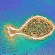
- The island is of volcanic origin and has an area of about 5.98 km² with a length of about 3 kilometers and a width of 1 kilometer. The highest elevation is the Otonbu-yama volcano at about 423 m above sea level. The island is also part of the Fuji-Hakone-Izu National Park.The Izu Archipelago – located south of Tokyo- is a scattering of small and mostly unoccupied islands in the Philippine Sea.
- Aogashima is an active volcano. Still considered a Class-C active volcano by the Japan Meteorological Agency, the last eruption of Aogashima was during a four-year period from 1781–1785.
- the island is a huge volcano crater, and another, smaller crater sticks out of this volcano.Caldera is a circus-shaped depression with steep walls and a more or less flat bottom, formed as a result of the collapse of the top of the volcano and, in some cases, the surrounding area. The diameter of the caldera on the island of Aogashima is about 1.5 kilometers.
- Hiking : climb the highest point (432 m) and see the panorama, go around volcanoes along pleasantly trodden paths.
- The island has been recognised as an Important Bird Area (IBA) by BirdLife International
- Otonbu : It is a mountain with an altitude of 423m located northwest of Sotowayama, and is also the highest point on Aogashima.
- There is a shrine called Fuji-sama in the middle of the Maruyama promenade, which has been constructed so that you can go around the inner ring mountain.
Go next : Hachijōjima , an island in Tokyo prefecture, some 300 kilometers south of Tokyo city./ Izu Oshima – largest and nearest of the Izu Islands.