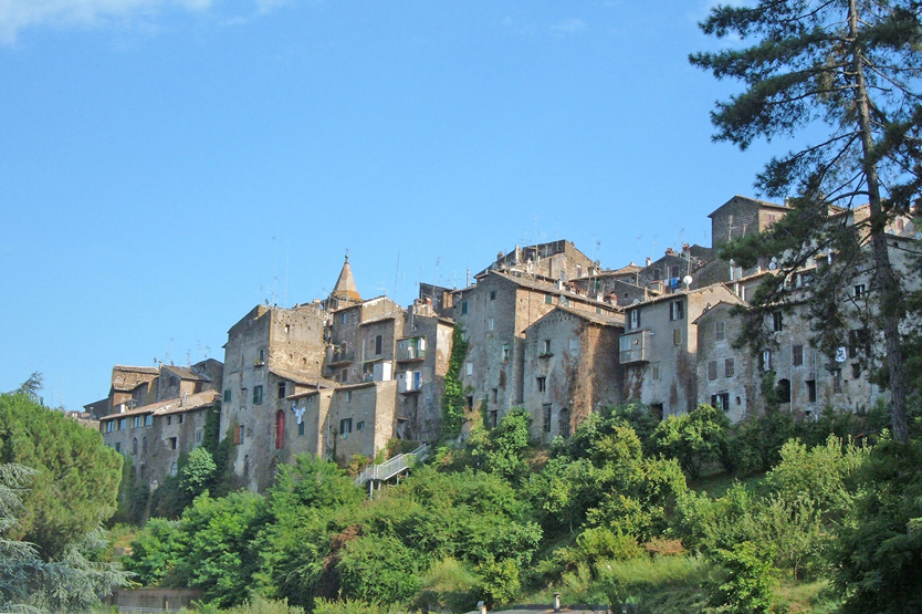
Capranica is a town , located in the province of Viterbo in northern Lazio, precisely in Tuscia , in Italy.
Capranica lies on the edge of the Monti Cimini between Lake Bracciano and Lake Vico.The land of Capranica is rather flat in the south-east, but in the north-west it is hilly.
The first settlements on the territory of the current Capranica date back to the Etruscan era, but the first certain information dates back to around 1050.
Under the cardinal-governors the town was enlarged and, especially before 1700, the most important palaces were built there. In 1831 Pope Leo XII removed the title of capital from Capranica.
There are many churches to visit of strong artistic and folkloristic interest. In September, the Procession of the Cocciarelle arrives at the Church of the Madonna del Piano, with the Vignola façade, so called because once the sellers of earthenware and terracotta crafts.
Among the civil monuments, Capranica is often recognized for the Sant’Antonio gate and the Anguillara castle with the clock tower.
Access : Coordinates: 42.25, 12.166667 / Capranica is located in the province of Provincia di Viterbo and region of Lacio, in the central part of the country, 50 km northwest of Rome the capital of the country.
Highlights :
- The original late-Romanesque bell tower of the Church of Santa Maria, perhaps from 1200, and the Romanesque Church of San Francesco restored by Antonio Muñoz in 1927
- The north side of Kapranica Square is occupied by the palace of the same name – a powerful brown building with a rather clumsy facade, which clearly lacks windows.
- The Capranica Square itself, its name is associated with the palace, which was built in 1450 by Cardinal Domenico Capranica / Porta di Sant’Antonio (St Anthony’s Gate) erected in the 17th century by Cardinal Antonio Barberini.
- Villa Paola : It was built in the first half of the 1600s by the nobleman Msgr. Sebastiano de Paoli, bishop of Nepi and Sutri.
- Sansoni Palace formerly Montenero : Probably built in the second half of the eighteenth century by the scholar Thierry in sixteenth-century forms that have given rise to various errors of historical and artistic evaluation.
- Church of the Madonna del Piano : It was built between the end of the 12th century and the beginning of the 14th century in the homonymous locality of the Piano, just outside the city walls, based on a design by Vignola.The church of Santa Maria del Piano has an elegant wooden ceiling and some frescoes attributed to the Zuccari brothers.
- Governor’s Palace : Built in the second half of the 15th century. on the return of Capranica under the dominion of the Church on the initiative of the governor Pietro Riario.
- The castle : Little remains of the castle due to the destruction carried out by order of Sixtus IV in 1485 after the fall of the Anguillara family.
- S. Sebastiano Hospital : It is notable for the presence of a Romanesque portal, an element recovered from an archaeological excavation, located at the entrance to the nineteenth-century building.
- Church of S. Terenziano : Isolated from the city, it has several interesting frescoes. The cult of S. Terenziano dates back to 1260 when Pandolfo II d’Anguillara sacked Todi and stole the relics of the saint, taking them to Capranica. The church has 15th and 17th century frescoes, always with the figure of the patron saint in the center.
- Saint Terentian is the patron saint of the commune, celebrated on 1 September./Among the cultural and folkloristic initiatives, the three main religious festivals, that of the SS. Sacramento (1st Sunday of May), of Maria SS. delle Grazie (2nd Sunday of May), of San Terenziano Patrono (1st Sunday of September), which take place over several days and present a full calendar of religious, sporting and entertainment initiatives.
- On the Via Francigena there is the “Museum of the Confraternities of Capranica”, which offers the opportunity to examine one of the most characteristic aspects of Capranica.
- Via Francigena : The Route of the Franks is the second most popular after the Route of St. Jacob’s pilgrimage route of medieval Europe. The inhabitants of England and France followed it to Rome, and the Italians to the north, to Canterbury. When driving north, it was called the road of the Franks, and when moving south, it was called the road of the Romans.
Go next : visit the remains of Etruscan and Roman artefacts, such as the “Castellaccio”, and the remains of “Vicus Matrini”, the first human settlement in the area. / Capranica is 25 km from the provincial capital Viterbo / Orvieto is a city in Umbria. / Lake Bolsena is to the southeast of Orvieto in the province of Lazio.


