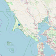
The Point Reyes National Seashore is a protected area on the Pacific coast in Marin County, approximately 55 kilometers north of San Francisco in the State of California. It covers almost the entire area of a geologically remarkable peninsula and a small strip of the ocean. Established on September 13, 1962 under US President John F. Kennedy, the 290 km² protected area is managed by the National Park Service and visited by more than two million visitors a year for hiking, camping and nature watching.
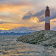
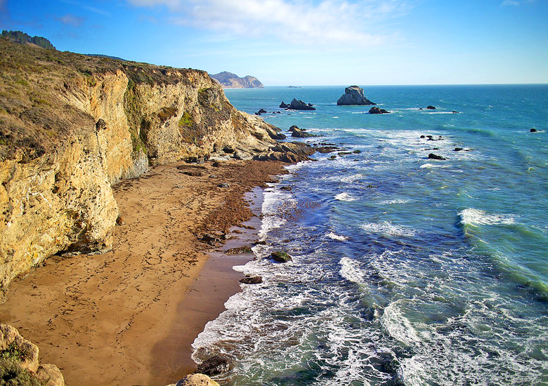
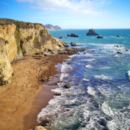
The more than two million visitors a year are mostly day visitors from the greater San Francisco area, for which Point Reyes is an important recreational area. Nearly 250 kilometers of hiking trails and 130 kilometers of untouched coastline attract mainly hikers. The cape with the lighthouse is the most visited place in the area. Swimming is not possible in the Pacific, the water is too cold year-round and the heavy surf is life-threatening. A small beach just outside the reserve on the flat and sheltered Tomales Bay.
Access : Coordinates: Location : Point Reyes National Seashore , Sir Francis Drake Blvd (at Sir Francis Drake Blvd) Point Reyes Station, CA 94956 , United States / 38.066667, -122.883333 / By car : from Highway 101, take Sir Francis Drake Boulevard west through Fairfax and western Marin county to Highway 1. Turn right, and take the first left . The next left is the entrance to the seashore.
It’s also possible to get to the park from Highway 1, north from Stinson Beach or south from Sonoma County. /
Public transportation to the Bear Valley Visitor Center from San Rafael along Sir Francis Drake Boulevard is available through the West Marin Stagecoach./

Attractions :
Chimney Rock- historic Chimney Rock Lifeboat Station , The 1.75-mile (2.8-km) round-trip Chimney Rock Trail leads along the ridge crest of a narrow peninsula,
Point Reyes Lighthouse ,1 Bear Valley Rd, Point Reyes National Seashore, CA 94956-9740 Open : 6:00 AM – 12:00 AM , This lighthouse is one of the foggiest in the country, and a great whale watching spot.
Cypress tree tunnel lane , The Monterey Cypress Tree Tunnel is 45 miles north of the Golden Gate Bridge./
Point Reyes Hiking Trails , Point Reyes National Seashore, CA 94956Open : 6:00 AM – 12:00 AM / over 147 mi (237 km) of hiking trails in the park. The park provides an official list of trails.
Mount Vision Road , Great views and the Highest point in the park ,
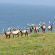
Tule Elk Preserve , 12320 Shoreline Highway, Tomales Bay Trailhead, Point Reyes National Seashore, CA 94956 ,Stunning views and hikes you will be happy to see so many elk and even a coyote
Limantour Beach , Limantour Road, Point Reyes National Seashore, CA , Great family beach with 2 access trails to get there.
Earthquake Trail , Bear Valley Rd, Point Reyes National Seashore, CA 94956 , Easy short Informative hike along the San Andreas fault.
Bear Valley Visitor Center , 1 Bear Valley Visitor Center Access Road, Point Reyes National Seashore, CA 94956 , Wonderful Visitor Center and Trails Easy to get to by public transportation.
Sculptured Beach , Point Reyes National Seashore, CA , / Marconi RCA Wireless Stations , 1 Bear Valley Rd Bldg 70, Point Reyes National Seashore, CA 94956-9703 , / Woodward Valley Trail , / Mount Wittenberg , the highest peak in the area, is great for hiking./
Kenneth C. Patrick Visitor Center , 1 Drakes Beach Rd, Point Reyes National Seashore, CA 94937-9712 ,
Visitor Center : Bear Valley Visitor Center , The Bear Valley Visitor Center is located 0.8 kilometer (0.5 mile) west of Olema, CA, along Bear Valley Road./ The Lighthouse Visitor Center and the Point Reyes Historic Lighthouse / Kenneth C. Patrick Visitor Center , The Kenneth C. Patrick Visitor Center is thirty minutes from Bear Valley on Drakes Beach off of Sir Frances Drake Boulevard./
Fees and permits : There are no entrance fees charged to visit Point Reyes. Permits are required for backcountry camping and for all fires. Overnight parking without a backcountry permit is not allowed.
Activities : treking , At the tip of Point Reyes is the end of the American Discovery Trail, a 10,800 kilometer long trek across the United States. / Wildlife viewing / Kayaking / San Francisco Seaplane Tour with Shuttle Transport /
having a picnic once to Tomales Point / Photography-Great photo ops !!! / Point Reyes Safaris / Food & Farm Tours
Nearby Attractions : Golden Gate National Recreation Area / Muir Woods National Monument / Samuel Taylor State Park / Tomales Bay State Park