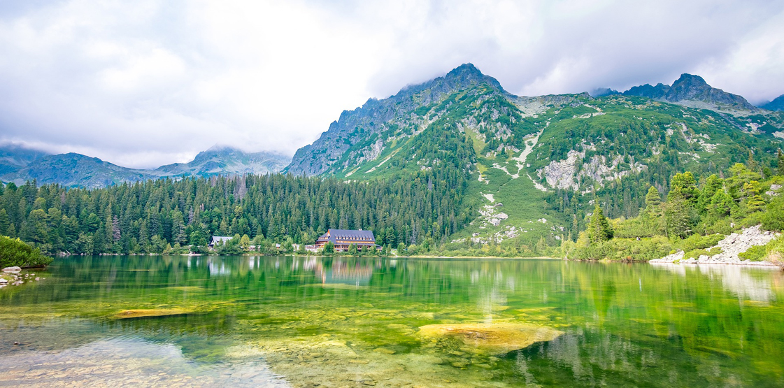
Popradské pleso is a alpine lake in the Mengusovská valley in the High Tatras in Slovakia.It is located in the Mengusovská dolina and its altitude is 1494 m above sea level.
Its area is 6.87 hectares, it measures around 380 × 250 m and is up to 17.6 m deep.Popradské pleso lies in the western part of the High Tatras, in the central part of the Mengusovská valley. The lake is frozen over from around mid-November to mid-May on average. On the north shore of the lake are two mountain huts, the Majláthova hut and the hut pri Popradskom plese.
Popradské pleso is one of the most popular tourist destinations in the High Tatras. There are several hiking trails, a symbolic cemetery, a chalet and a restaurant. The lake is accessible on foot all year round. A road leads to the cottage, along which it is possible to reach by bike, and only for guests and on special permission also by car.
Access : Coordinates: 49.1531, 20.0803 / Popradské pleso can be reached all year round via an asphalted forest road (blue hiking trail) from the Popradské pleso stop of the Tatra Electric Railway (1:00 h) or via the red hiking trail from Štrbské Pleso (1:00 h in summer, 1:15 h in the winter). Access by car is only possible with a special permit. The lake can only be reached in summer from the Sliezsky dom hut via the Batizovské pleso mountain lake (3:30 h).
Highlights :
- On the shores of the lake there is a chalet at the Popradzki pond and a chalet Majlátha. Every year in early autumn, THS celebrations are held at the pond, on this occasion, demonstrations of the skills of rescuers are held on the slopes of Osterwa.
- From Popradské pleso you can go on hikes to surrounding destinations around the Mengusovská dolina and in the Kotlina Žabích plies , including to the largest mountain lake in Slovakia, Veľké Hincovo pleso, or to the Polish-Slovak border mountain Rysy.
- The Memorial : About 10 minutes walk south of the lake , at the foot of the impressive Osterva massif, is the symbolic Tsintorin Memorial for all fallen tourists and climbers in the Tatras, with plaques in memory of Otakar Stafel, Jerzy Kukuchka, Vande Rutkevich and other famous climbers. The memorial is under special protection of the administration of the Slovak Tatra National Park.
- The Trails , the Lake has become a starting point for many tourists to Rysy, which are known for their beautiful scenic views: Blue trail – from the Popradské pleso electric railway station to Popradzki Staw and further up the Mięguszowiecka Valley to the fork with the red trail to Rysy. / Blue trail in the Mięguszowiecka Valley. Walking time: 45 minutes both ways / The red and yellow trails are open only in the summer season (June 16 – October 31 / The red trail of the Tatra Magistrala – from the Szczyrbskie Lake to the Popradzki Staw, then through the pass near Osterwa to Batyżowieckie Pond. / The green trail – green from Lake Strbske, departing from the red trail after 30 minutes. Time of walking the entire route: 1:15 h, 1:05 h
- Many popular hikes including to Rysy ( Rysy a mountain on the Polish-Slovak border in the High Tatras. It has three peaks.2503 m , 2499.6 m,2473 m ) and Kôprovský štít
Activities : sightseeing / photo opportunities / trekking,A 1.3 km long tourist path leads around the lake. It also leads to the Tatra Symbolic Cemetery near Osterwa.
Go next : The town of Poprad, about 25 kilometers away / Skok Waterfall is one of the most beautiful and most visited waterfalls in the High Tatras and Slovakia / Velké Hincovo pleso is the largest and deepest lake in Slovakia / Štrbské pleso is one of the most famous places in the High Tatras.