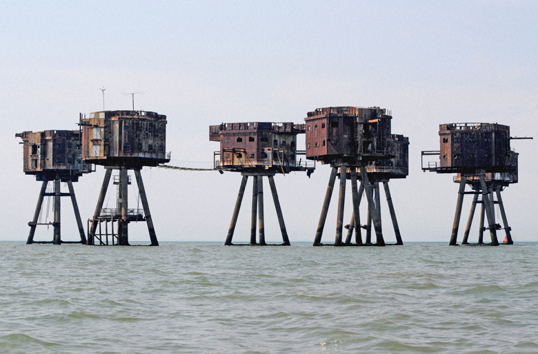
Shivering Sands is a Maunsell Fort in the Thames Estuary off the south east coast of England – .United Kingdom.
It is a group of seven pontoon platforms built for the British Army in World War II. The fort with the army name U7 was completed on 13 December 1943. It served the defense of German aircraft and speedboats that attacked the docks on the Thames and mined the navigation channels. In early 1946 it was cleared and closed and the armament dismantled. The Fort is empty today and can be considered dilapidated.
-( The Maunsell Marine Fortresses were small fortified towers that were built during World War II for the defense of the United Kingdom. They were located in the estuaries of the River Thames (London region) and Mersey (Liverpool region). They were named after their designer, Guy Maunsell. After removing them from service in the late 1950s, they went to other activities, and even one of them became the so-called “micronation” of Sealand.)
Pirate Radio : On May 27, 1964, Screaming launched Lord Sutch with Radio Sutch from a turret of Shivering Sands. Sutch sold his share of the station in the fall of 1964 to his manager Reg Calvert, who renamed it Radio City. The Port of London Authority complained regularly, the radio connection to the automatic measuring station in the headlight tower would be disturbed by the transmitter of Radio City. On June 20, 1966, following a property dispute, the station was forcibly conquered by a group of dockers and Calvert was shot dead when entering his adversary’s private home. Calvert’s widow definitively ceased Radio City operations in early 1967.
Today The entry ladders were sawn off, to prevent dangerous trespass. Nevertheless The structures stand empty, but not unloved. Project Redsand is a charity dedicated to maintaining the structures. It runs occasional boat trips for interested parties.
Armament and layout :
- A central command tower surrounded by five other towers in a circle around it,The fort was equipped with four heavy QF 3.7-inch Mk. VI anti-aircraft guns with Vickers electro-mechanical range finder calculator and two 40mm Bofors rapid-fire guns armed to combat low-flying targets. Five turrets clustered around the fire control tower, another tower with a searchlight stood a bit off the plant. He also housed three 30-kilowatt diesel generators that powered the system. The towers were connected to each other by catwalks. There was a crew of 165 men.
Access : Coordinates: 51.499167, 1.074667 / Location : 8 nautical miles (9.2 miles) from Herne Bay, and 8.75 nautical miles (10.06 miles) from Whitstable, Kent.
From Queenborough takes around an hour with favourable tides.
Activities : Explore Amazing Abandoned Sea Forts of World War II / photo opportunities
Go next : Queenborough / Canterbury – historic city, WV-Unesco-icon-small.svg UNESCO World Heritage site and seat of the Archbishop of Canterbury / Strood – one of the Medway Towns