Big Sur is a region on the Central Coast of California.-U.S.A. It contains vast wildernesses and breathtaking views as it stretches 72 miles along the rugged Pacific Ocean. While the region has no specific borders, most residents consider Big Sur to be bounded on the north by Malpaso Creek, approximately 129 miles south of San Francisco, and on the south by San Carpoforo Canyon, 244 miles north of Los Angeles.
The area is great for outdoor recreation and contains several state parks, two national wilderness areas, and is part of the Los Padres National Forest, all of which include hiking trails. The name during the Spanish colonial period was “el pais grande del sur”, meaning “the big country of the south”, referring to the vast relatively unexplored region south of the city of Monterey, which was the capital of Alta California under both Spain and Mexico. It was Anglicized as Big Sur by European settlers in 1915.
Big Sur begins a few miles south of Carmel and includes the small settlements of Palo Colorado Canyon, Big Sur Village (between Andrew Molera State Park and Pfeiffer Big Sur State Park), Posts, Lucia, and Gorda. It ends near San Simeon (where the Hearst Castle is located). When driving on Highway 1 through Big Sur, be alert for traffic conditions, especially during summer vacation periods and holiday weekends, when the northern portion of the highway can be congested. You can stop to admire the scenery at one of the many dirt turnouts and vista points along the route. When stopping at a viewpoint be sure that your vehicle is entirely off the roadway.
History : Three Native American tribes – the Ohlone, Esselen, and Salinan – are believed to have lived in Big Sur as hunter-gatherers prior to the arrival of Europeans. The Spanish explorer Juan Cabrillo was the first European to view the area when he sailed along the coast in 1542. Spaniards arrived on foot in 1769, but the high cliffs and rough terrain forced them inland. Monterey was settled in 1770, during which the Governor made only two lands grants in the area, Rancho El Sur and Rancho San Jose y Sur Chiquito. The ranchos were maintained by caretakers.
Mexico took control of the area when it gained independence from Spain in 1821, and in 1848 Mexico ceded California to the United States following the Mexican-American War. By 1862, several pioneers had moved into the area, although the inaccessibility of the area prevented any significant development.
The construction of the present-day Highway One began in 1919 using convict labor. Construction stopped in 1924 when funds were exhausted and resumed in 1928. Construction required 33 bridges to be built and thousands of tons of dynamite to blast the road through the coastal cliffs. The $10 million, unpaved Carmel-San Simeon Highway was finally opened in 1937. Over the years, Monterey County lawmakers and local residents have established extremely tough development restrictions, making it illegal to build almost anything within view of the highway and other public points. As of 2018, only about 1,000 residents live on the coast year-round.
Access : Coordinates: / Big Sur is a remote area accessible only via Highway 1 (also known as Pacific Coast Highway) or via the winding, narrow 25 mile long Nacimiento-Fergusson Road, accessible from Highway 101 and Jolon, California. Highway 1 winds through Big Sur flanked by the steep Santa Lucia Mountains to the east and the rocky Pacific Coast to the west. The easiest and most common way to get to Big Sur is by car, though some enthusiastic adventurers cycle along the highway. There are only four gas stations along the route and fuel is expensive, so fill your tank before entering the Big Sur region. The highway is prone to rock and mud slides which have been so severe in the past that the highway has sometimes closed for over a year. Construction can also cause delays or closures, so check California highway road conditions prior to setting out. The Nacimiento-Fergusson Road is the only alternative route.
From San Francisco take US-101 south to CA-156 west which merges with Highway 1 20 miles from MalPaso Canyon. Approximately 129 miles and 2-3 hour drive.
From Los Angeles take US-101 north and exit onto Highway 1 toward Morro Bay/Hearst Castle, about 45 miles south of San Carpoforo Canyon. Approximately 244 miles and 4-5 hour drive.
Monterey-Salinas Transit route 22 bus, toll-free: Runs from downtown Monterey to Nepenthe in Big Sur. It runs several times a day, seven days a week from Memorial Day to Labor Day (last week of May through first week of September), and on weekends during the rest of the year. It stops at several state parks, the Big Sur River Inn, and Nepenthe. During winter and spring, the bus is sometimes canceled due to bad weather, so call ahead to ensure that it is operating.
Highlights :
- Garrapata State Park (18 miles north of Big Sur Village). The 2,939-acre park was established in 1979 and offers two miles of beachfront, with coastal hiking and a 50-foot climb to a beautiful view of the Pacific. Trails lead from the ocean into dense redwood groves. Sea lions, harbor seals and sea otters are frequently seen in the waters.
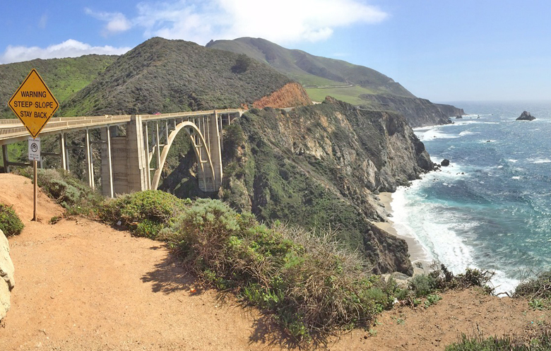
- Bixby Bridge (11 miles north of Big Sur Village). Iconic bridge built in 1933. One of the most photographed in the world because of its location within such beautiful scenery. The concrete arch spans 320 feet (98 m), and its 280 foot (85 m) height makes it one of the tallest single-span concrete bridges in the world. Be sure to park entirely off the road. Do not block the Old Coast Road on the inland side of Bixby Creek Bridge.
- Point Sur Lighthouse (5 miles north of Big Sur Village). Point Sur is a dominant feature along Highway 1. It is a National Historic Landmark and is one of the only complete turn-of-the-century light stations open to the public in California. It is also allegedly one of the most haunted places in America. Spectacular views can be had from atop Point Sur. Tours (3 hours) are offered – meet west side of highway at farm gate a quarter mile north of Pt Sur Naval Facility. Winter times Sa, Su 10AM, W 1PM. $10 adult, $5 children.
- Pfeiffer Big Sur State Park (2 miles south of Big Sur Village). There are hiking trails through redwood groves. It is a 1.4 mile round trip to 60-foot Pfeiffer Falls that runs from Dec to May.
- Julia Pfeiffer Burns State Park (12 miles south of Big Sur Village). The 3,762-acre park was established in 1962 and is home to McWay Falls, one of the most spectacular places anywhere in Big Sur. The falls drop 80 feet onto the beach or tide. There is a hike out to a view point but it can also be seen from the road just before Julia Pfeiffer Burns State Park. The park is also home to ancient coast redwoods that stand 300 feet tall and are over 2,500 years old. The beach is not accessible due to hazardous cliffs.
- New Camaldoli Hermitage (located in Lucia off Highway 1 (25 miles south of Big Sur village). Monastery offering guided retreats; also sells gifts and food items.
- Pfeiffer Beach (Two miles west of Highway 1 near Posts). 9:00 a.m. to 8:00 p.m.. Pfeiffer Beach is known for its purple sand and the huge rock towers that emerge from the water, one of which has a natural tunnel through which the sunset can be viewed at the right time of year. Reaching the beach can be challenging – Sycamore Canyon road is easy to miss from Highway One, the winding road is one-lane and shared with local residents, and the parking area only accommodates sixty vehicles and is often full. The area is managed by the US Forest Service, which charges a day-use fee of $10. Pfeiffer Beach is NOT accessible from Pfeiffer Big Sur State Park. $10 day use fee per vehicle $30 per shuttle/tour bus.
Beaches : Remote and pristine beaches are accessible. Andrew Molera State Park, Pfeiffer Beach, and Sand Dollar Beach are the most commonly visited.
- Andrew Molera State Park (Less than 1 mile north of Big Sur Village). Miles of trails, beaches, and meadows. Also has 24 primitive camp sites (first come, first serve).
- Pfeiffer Beach (2.5 miles south of Big Sur Village turn west on Sycamore Canyon Rd (unmarked road, only paved and non-gated road to the west in the area). Great sunsets and a fun beach, with sand that has a purple hue due to manganese garnet (dig down a bit to find it) and a rock formation famous with photographers due to a natural keyhole through which the sunset shines. Swimming is possible although there is a strong undertow.
- Point Lobos State Reserve (24 miles north of Big Sur Village (just south of Carmel). Well managed and developed recreation area offering many hikes, beaches, coves and points. Also offers SCUBA by permit only. Often referred to as the crown jewel of the State Park System. $10 per car.
- Sand Dollar Beach (35 miles south of Big Sur Village (across Highway 1 from Plaskett Creek Campground). Stairs lead to the beach. Largest expanse of sand in Big Sur and also well protected from wind. $10 per car.
- McWay Falls is a 24-meter-high waterfall in Julia Pfeifer Burns State Park,in the coastal region of Big Sur, in Monterey County.
Go next : the town of Carmel / San Simeon / Monterey / N California / San Luis Obispo / Avila Beach / Carrizo Plain National Monument.